NWS Louisville
NWS Louisville Briefing: July 9th, 2026

- Title
- NWS Louisville Briefing: July 9th, 2026
- Runtime
- 13:30
- Date posted
- 11 days ago
- Description
- Conference call for the heavy rain and severe thunderstorm potential for tonight through this weekend, July 9-12, 2026.
---------------------------------
National Weather Service
Weather Forecast Office
Louisville, KY

- Title
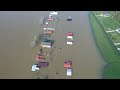
- NWS Flood Survey Drone Footage Lanesville and Corydon, Indiana June 9, 2026
- Runtime
- 2:35
- Date posted
- 12 days ago
- Description
- NWS Flood Survey Drone Footage Lanesville and Corydon, Indiana June 9, 2026. Special thanks to US Coast Guard for their assistance in capturing this drone footage.
---------------------------------
National Weather Service
Weather Forecast Office
Louisville, KY

- Title
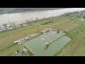
- NWS Flood Survey Drone Footage at Tates Creek in Madison County, KY June 27, 2026.
- Runtime
- 1:09
- Date posted
- 12 days ago
- Description
- NWS Flood Survey Drone Footage at Tates Creek in Madison County, KY June 27, 2026. Special thanks to US Coast Guard for their assistance in capturing this drone footage.
---------------------------------
National Weather Service
Weather Forecast Office
Louisville, KY

- Title
- Oldham County Straight-line Wind Damage from severe storms April 27, 2026
- Runtime
- 4:00
- Date posted
- 3 months ago
- Description
- Oldham County storm damage from up to 90 mph straight-line winds that occurred the evening of April 27, 2026.
Location: Hannah Rd south of Ballardsville, KY.
Drone footage courtesy of Oldham County Aerial Response Team.
---------------------------------
National Weather Service
Weather Forecast Office
Louisville, KY

- Title
- NWS Louisville Severe Weather Briefing April 27, 2026
- Runtime
- 6:53
- Date posted
- 3 months ago
- Description
- Weather briefing Monday morning April 27, 2026 for multiple rounds of strong to severe storms Monday Night into early Tuesday morning (April 27-28) and Tuesday afternoon into Tuesday overnight (April 28-29)
---------------------------------
National Weather Service
Weather Forecast Office
Louisville, KY

- Title
- NWS Louisville Severe Weather Briefing April 26, 2026
- Runtime
- 6:56
- Date posted
- 3 months ago
- Description
- Weather briefing Sunday evening April 26, 2026 for multiple rounds of strong to severe storms Monday Night into early Tuesday morning (April 27-28) and Tuesday afternoon into Tuesday overnight (April 28-29)
---------------------------------
National Weather Service
Weather Forecast Office
Louisville, KY

- Title
- NWS Louisville Severe Weather Briefing April 24, 2026
- Runtime
- 4:37
- Date posted
- 3 months ago
- Description
- Weather briefing Friday morning April 24th 2026 for storms on Friday afternoon, Weekend Weather and Potential Severe Weather Threat Monday April 27th.
---------------------------------
National Weather Service
Weather Forecast Office
Louisville, KY

- Title
- NWS Louisville Severe Weather Briefing March 15, 2026
- Runtime
- 6:02
- Date posted
- 4 months ago
- Description
- Wind Advisory Sunday afternoon into Monday Morning, with severe weather is expected Sunday night March 15th, 2026. Here is the latest on the threat
---------------------------------
National Weather Service
Weather Forecast Office
Louisville, KY

- Title
- NWS Louisville Severe Weather Briefing March 14, 2026
- Runtime
- 6:35
- Date posted
- 4 months ago
- Description
- Severe weather is expected Sunday night March 15th, 2026. Here is the latest on the threat
---------------------------------
National Weather Service
Weather Forecast Office
Louisville, KY

- Title
- EDIT: What/When/Where (e.g. Strong Cold Front Moving Through Saturday)
- Runtime
- 0:00
- Date posted
- 5 months ago
- Description
- EDIT: Provide a short description describing the content of the video. Leave the "signature" below in every video.
---------------------------------
National Weather Service
Weather Forecast Office
Louisville, KY

- Title
- NWS Louisville Severe Weather Briefing February 19, 2026
- Runtime
- 11:10
- Date posted
- 5 months ago
- Description
- Severe weather is expected, mainly for southern Indiana, for the afternoon and evening of February 19, 2026.
---------------------------------
National Weather Service
Weather Forecast Office
Louisville, KY

- Title
- Recorded Conference Call - Thurs. 12-11-25 Winter Weather Impacts from snow and cold
- Runtime
- 23:36
- Date posted
- 7 months ago
- Description
- Recorded afternoon conference call from Thursday December 11, 2025 winter impacts from multiple rounds of snow followed by very cold temperatures.
Detail forecast: https://www.weather.gov/forecastpoints/
---------------------------------
National Weather Service
Weather Forecast Office
Louisville, KY

- Title
- NWS Louisville: Severe Weather Expected June 18th, 2025
- Runtime
- 3:13
- Date posted
- 1 year ago
- Description
- Severe weather confidence is increasing for later today and tonight.
---------------------------------
National Weather Service
Weather Forecast Office
Louisville, KY

- Title
- EF2 Tornado Damage near Pottsville, KY May 30th 2025
- Runtime
- 9:54
- Date posted
- 1 year ago
- Description
- Drone footage covering damage from EF2 tornado near Pottsville in Washington County, KY on May 30th, 2025
---------------------------------
National Weather Service
Weather Forecast Office
Louisville, KY

- Title
- NWS Flood Survey Drone Footage Madison, IN and Hanover Beach, IN April 8th and 9th, 2025.
- Runtime
- 8:43
- Date posted
- 1 year ago
- Description
- NWS Flood Survey Drone Footage Madison, IN and Hanover Beach, IN April 8th and 9th, 2025. Flight times approximately between 2:30-3 PM EDT April 8th in Madison and 1:00-1:30 PM EDT April 9th at Hanover Beach. Drone footage courtesy of Jefferson County, IN EMA.
---------------------------------
National Weather Service
Weather Forecast Office
Louisville, KY

- Title
- NWS Flood Survey Drone Footage Cannelton, IN April 8, 2025.
- Runtime
- 12:22
- Date posted
- 1 year ago
- Description
- NWS Flood Survey Drone Footage Cannelton, IN April 8, 2025. Flight times approximately between 3:00 and 6:00 PM CDT. Drone footage courtesy of Construction Engineering Solutions and Construction Technology Solutions.
---------------------------------
National Weather Service
Weather Forecast Office
Louisville, KY

- Title
- NWS Flood Survey Drone Footage Tell City, IN April 7, 2025.
- Runtime
- 5:50
- Date posted
- 1 year ago
- Description
- NWS Flood Survey Drone Footage Tell City, IN April 7, 2025. Flight times approximately between 3:00 to 6:00 PM CDT. Drone footage courtesy of Construction Engineering Solutions and Construction Technology Solutions.
---------------------------------
National Weather Service
Weather Forecast Office
Louisville, KY

- Title
- NWS Flood Survey Drone Footage Troy, IN April 8, 2025.
- Runtime
- 3:58
- Date posted
- 1 year ago
- Description
- NWS Flood Survey Drone Footage Troy, IN April 8, 2025. Flight times approximately between 3:00 and 6:00 PM CDT. Drone footage courtesy of Construction Engineering Solutions and Construction Technology Solutions.
---------------------------------
National Weather Service
Weather Forecast Office
Louisville, KY
- Title
- NWS Flood Survey Drone Footage Charlestown, IN April 10, 2025.
- Runtime
- 6:44
- Date posted
- 1 year ago
- Description
- NWS Flood Survey Drone Footage Charlestown, IN April 10, 2025. Flight time at approximately 9:44 AM EDT. Flight path along River Rd W near Bushman Lake Rd. and along Rivers Edge Dr. Drone footage courtesy Clark County Emergency Management and Clark County Sheriff's Office.
---------------------------------
National Weather Service
Weather Forecast Office
Louisville, KY

- Title
- NWS Flood Survey Drone Footage Frankfort, KY April 7, 2025.
- Runtime
- 11:49
- Date posted
- 1 year ago
- Description
- NWS Flood Survey Drone Footage Frankfort, KY April 7, 2025. Drone footage courtesy of Frankfort Police Department.
---------------------------------
National Weather Service
Weather Forecast Office
Louisville, KY

- Title
- NWS Flood Survey Drone Footage Lockport, KY April 8, 2025
- Runtime
- 9:01
- Date posted
- 1 year ago
- Description
- NWS Flood Survey Drone Footage Lockport, KY April 8, 2025. Flight times from approximately 11:18 AM to 11:42 AM EST.
---------------------------------
National Weather Service
Weather Forecast Office
Louisville, KY

- Title
- NWS Flood Survey Drone Footage Hartford, KY April 9, 2025
- Runtime
- 2:00
- Date posted
- 1 year ago
- Description
- NWS Flood Survey Drone Footage Hartford, KY April 9, 2025. Flight times from approximately 10:29 AM to 10:33 AM EST.
---------------------------------
National Weather Service
Weather Forecast Office
Louisville, KY

- Title
- NWS Flood Survey Drone Footage Dundee, KY April 9, 2025
- Runtime
- 3:30
- Date posted
- 1 year ago
- Description
- NWS Flood Survey Drone Footage Dundee, KY April 9, 2025. Flight times from approximately 9:37 AM to 9:47 AM CST.
---------------------------------
National Weather Service
Weather Forecast Office
Louisville, KY

- Title
- NWS Flood Survey Drone Footage Westpoint, KY April 9, 2025
- Runtime
- 7:04
- Date posted
- 1 year ago
- Description
- NWS Flood Survey Drone Footage Westpoint, KY April 9, 2025. Flight time from approximately 8:40 AM to 9:07 AM EST.
---------------------------------
National Weather Service
Weather Forecast Office
Louisville, KY

- Title
- NWS Flood Survey Drone Footage Woodbury, KY April 10, 2025
- Runtime
- 3:20
- Date posted
- 1 year ago
- Description
- NWS Flood Survey Drone Footage Woodbury, KY April 10, 2025. Flight times from approximately 8:56 AM to 10:02 AM CST.
---------------------------------
National Weather Service
Weather Forecast Office
Louisville, KY

- Title
- NWS Flood Survey Drone Footage Rochester, KY April 10, 2025
- Runtime
- 3:24
- Date posted
- 1 year ago
- Description
- NWS Flood Survey Drone Footage Rochester, KY April 10, 2025. Flight times approximately from 10:49 AM to 11:42 AM CST.
---------------------------------
National Weather Service
Weather Forecast Office
Louisville, KY

- Title
- NWS Louisville: Storm Update 9 AM EDT Saturday April 5th
- Runtime
- 8:56
- Date posted
- 1 year ago
- Description
- Severe flooding risk for today and tonight.
---------------------------------
National Weather Service
Weather Forecast Office
Louisville, KY

- Title
- NWS Louisville Update Friday April 4th, 2025
- Runtime
- 8:50
- Date posted
- 1 year ago
- Description
- EDIT: Provide a short description describing the content of the video. Leave the "signature" below in every video.
---------------------------------
National Weather Service
Weather Forecast Office
Louisville, KY

- Title
- (Afternoon Update) NWS Louisville: Severe Threat for April 2nd, 2025
- Runtime
- 5:03
- Date posted
- 1 year ago
- Description
- Afternoon Update 4/2/25 - Severe weather is possible for many locations in Kentucky for Wednesday, April 2nd, 2025. Large hail, damaging wind, and tornadoes are all possible. There is also an increased flooding potential due to high rainfall amounts over the next several days. Please stay weather aware Wednesday night, think about your severe weather plan, and have multiple ways to receive warnings.
---------------------------------
National Weather Service
Weather Forecast Office
Louisville, KY

- Title
- NWS Louisville: Severe Threat for April 2nd, 2025
- Runtime
- 2:14
- Date posted
- 1 year ago
- Description
- Severe weather is possible for many locations in Kentucky for Wednesday, April 2nd, 2025. Large hail, damaging wind, and tornadoes are all possible. There is also an increased flooding potential due to high rainfall amounts over the next several days. Please stay weather aware Wednesday night, think about your severe weather plan, and have multiple ways to receive warnings.
---------------------------------
National Weather Service
Weather Forecast Office
Louisville, KY

- Title
- NWS Louisville: Video Briefing for Severe Weather Sunday March 30th, 2025
- Runtime
- 4:38
- Date posted
- 1 year ago
- Description
- Severe weather is possible for many locations in Kentucky for Sunday, March 30th. Large hail, damaging wind, and tornadoes are all possible. Please stay weather aware Sunday night, think about your severe weather plan, and have multiple ways to receive warnings.
---------------------------------
National Weather Service
Weather Forecast Office
Louisville, KY
- Title
- What can I expect for where I live? Navigating Weather.gov & Getting a an Hour-by-Hour Forecast.
- Runtime
- 5:58
- Date posted
- 2 years ago
- Description
- Probably the most asked questions to the weather office is before a big weather event is, "When will the precipitation start for my location?" or "How much snow/ice or rain will I get?" You can find an hour-by-hour break down of weather conditions for your location via https://weather.gov/forecastpoints and https://weather.gov/louisville
---------------------------------
National Weather Service
Weather Forecast Office
Louisville, KY

- Title
- Why have the skies been so hazy? Because of wildfire smoke
- Runtime
- 1:18
- Date posted
- 2 years ago
- Description
- The last few days have been nice with lots of sunshine, but some of that sun has been obscured by smoke from wildfires burning across the Pacific Northwest and north-central Canada
---------------------------------
National Weather Service
Weather Forecast Office
Louisville, KY

- Title
- NWPS Demo
- Runtime
- 20:30
- Date posted
- 2 years ago
- Description
- Recording of the NWPS (National Water Prediction Service) Demo from the webinar on 4/29/24.
---------------------------------
National Weather Service
Weather Forecast Office
Louisville, KY

- Title
- Friday (5/24/24) Afternoon Conference Call Regarding Severe Weather Potential Sunday May 26, 2024
- Runtime
- 23:07
- Date posted
- 2 years ago
- Description
- Recorded afternoon conference call from Friday May 24, 2024 for the severe weather potential for Sunday May 26, 2024
---------------------------------
National Weather Service
Weather Forecast Office
Louisville, KY

- Title
- NWS Louisville Damage Survey Drone Footage May 8th, 2024
- Runtime
- 1:30
- Date posted
- 2 years ago
- Description
- Here's the drone footage near Perry Crossings (outside of Sellersburg) of the damage from the tornado on May 7th, 2024 (EF0 85 mph). Check out the ground swirls in the field outside of the housing development!
---------------------------------
National Weather Service
Weather Forecast Office
Louisville, KY

- Title
- 50 Years Later, Stories from April 3rd, 1974: Stewart Surgener
- Runtime
- 11:44
- Date posted
- 2 years ago
- Description
- On April 3rd 1974 the lives of many across the Midwest, and those here across Kentucky and Indiana, changed forever. Even 50 years later those who lived through that day have a story to tell. This story is from Louisville native Stewart Surgener.
---------------------------------
National Weather Service
Weather Forecast Office
Louisville, KY

- Title
- 2024 Advanced Skywarn Training Facilitated by NWS Louisville, KY
- Runtime
- 2:59:14
- Date posted
- 2 years ago
- Description
- Advanced Skywarn Training featuring basic spotter review, thunderstorm ingredients, visual clues, and a special emphasis on Derechos.
---------------------------------
National Weather Service
Weather Forecast Office
Louisville, KY

- Title
- Tornado damage across Beechland Beach and Prospect Kentucky area from April 2, 2024 tornado
- Runtime
- 0:24
- Date posted
- 2 years ago
- Description
- A tornado swept through portions of the Louisville metro area during the afternoon hours of April 2, 2024. Storm damage survey crews from the National Weather Service documented this damage with drones.
---------------------------------
National Weather Service
Weather Forecast Office
Louisville, KY

- Title
- 50 Years Later, Stories from April 3rd, 1974: Phil Schaad
- Runtime
- 10:08
- Date posted
- 2 years ago
- Description
- On April 3rd 1974 the lives of many across the Midwest, and those here across Kentucky and Indiana, changed forever. Even 50 years later those who lived through that day have a story to tell. This story is from Louisville native Phil Schaad.
---------------------------------
National Weather Service
Weather Forecast Office
Louisville, KY

- Title
- 50 Years Later, Stories from April 3rd, 1974: Beth Watkins
- Runtime
- 4:43
- Date posted
- 2 years ago
- Description
- On April 3rd 1974 the lives of many across the Midwest, and those here across Kentucky and Indiana, changed forever. Even 50 years later those who lived through that day have a story to tell. This story is from Louisville native Beth Watkins.
---------------------------------
National Weather Service
Weather Forecast Office
Louisville, KY

- Title
- NWS Drone Video of EF2 Tornado Damage Near Milton, KY - March 14, 2024
- Runtime
- 1:54
- Date posted
- 2 years ago
- Description
- NWS damage survey teams used drones to get a better view of the EF2 tornado damage near the Ohio River and Milton, KY. This damage occurred from a tornado on March 14, 2024.
---------------------------------
National Weather Service
Weather Forecast Office
Louisville, KY

- Title
- Drone View of EF2 Tornado Damage - Jefferson County, IN March 14, 2024
- Runtime
- 0:25
- Date posted
- 2 years ago
- Description
- NWS drone video of EF2 damage near the Sandy Beach campground. The tornado occurred on March 14, 2024.
---------------------------------
National Weather Service
Weather Forecast Office
Louisville, KY
- Title
- EF2 Tornado Damage near Sandy Beach Campground - March 15, 2024
- Runtime
- 1:03
- Date posted
- 2 years ago
- Description
- EF2 tornado caused damage along the Ohio River near Sandy Beach Campground in Jefferson County, Indiana on March 14, 2024. NWS drone video captures the extent of damage from above.
---------------------------------
National Weather Service
Weather Forecast Office
Louisville, KY

- Title
- EF1 Tornado Damage near Hanover, IN March 15th, 2024
- Runtime
- 1:28
- Date posted
- 2 years ago
- Description
- This drone footage was taken by the NWS storm survey team in the Jefferson Manor neighborhood near Hanover, Indiana.
---------------------------------
National Weather Service
Weather Forecast Office
Louisville, KY
- Title
- When Will it Rain/Snow for Me? Navigating Weather.gov & Getting the Hour-by-Hour Forecast
- Runtime
- 4:42
- Date posted
- 3 years ago
- Description
- Probably the most asked question to the weather office is, "When will the precipitation start for my location?" You can find an hour-by-hour break down of weather conditions for your location via https://weather.gov/louisville
---------------------------------
National Weather Service
Weather Forecast Office
Louisville, KY
![EF-2 Tornado Damage south of Russellville, KY [December 9, 2023 storms]](https://i.ytimg.com/vi/0s42c6AveA0/3.jpg)
- Title
- EF-2 Tornado Damage south of Russellville, KY [December 9, 2023 storms]
- Runtime
- 0:26
- Date posted
- 3 years ago
- Description
- NWS Louisville conducted a storm damage survey in Logan County from storms that impacted the region on December 9th, 2023. EF-2 damage was observed in Logan County. This tornado started in northern TN earlier in the afternoon and caused EF-3 damage in the Clarkesville area before moving into Kentucky and eventually impacting Logan County.
---------------------------------
National Weather Service
Weather Forecast Office
Louisville, KY

- Title
- Tornado damage on the northern side of Paoli, Indiana (from 8/7/23 tornado)
- Runtime
- 0:25
- Date posted
- 3 years ago
- Description
- NWS Louisville conducted a storm damage survey on the northern side of Paoli, IN, and determined an EF-1 tornado with 100mph winds was on the ground for about 1 mile. This tornado occurred in the early morning hours of August 7, 2023.
---------------------------------
National Weather Service
Weather Forecast Office
Louisville, KY

- Title
- Tornado Damage over Paoli, IN (from early morning August 7, 2023, storms)
- Runtime
- 0:20
- Date posted
- 3 years ago
- Description
- EF-1 tornado damage was observed across portions of Paoli after a line of storms moved through the area during the early morning hours of August 7, 2023.
---------------------------------
National Weather Service
Weather Forecast Office
Louisville, KY

- Title
- Russell County Tornado Damage from June 25-26, 2023
- Runtime
- 2:11
- Date posted
- 3 years ago
- Description
- A brief EF1 tornado occurred near Jamestown, Kentucky on the night of June 25th, 2023. This video is drone footage of the damage.
---------------------------------
National Weather Service
Weather Forecast Office
Louisville, KY