NWS Louisville
Evening Weather Forecast Tuesday 11-29-22 - Update on strong to severe storms overnight

- Title
- Evening Weather Forecast Tuesday 11-29-22 - Update on strong to severe storms overnight
- Date posted
- 3 years ago
- Description
- Tuesday evening weather forecast (11/29/22): Strong to severe storms moving through this evening and a few more showers/storms are likely overnight as a cold front moves across central KY/southern IN. More at https://www.weather.gov/lmk/
---------------------------------
National Weather Service
Weather Forecast Office
Louisville, KY

- Title
- Morning Weather Forecast Saturday 11-12-22 - Wintry start to the weekend
- Date posted
- 3 years ago
- Description
- Saturday morning weather forecast (11/12/22): Burst of wintry weather working across central KY and southern IN. Roads are getting slushy, ground covered. Most of the precipitation will end by midday More at https://www.weather.gov/lmk/
---------------------------------
National Weather Service
Weather Forecast Office
Louisville, KY

- Title
- Morning Weather Forecast Thursday 10-27-22 - Some morning river fog
- Date posted
- 4 years ago
- Description
- Thursday morning weather forecast (10/27/22): Some fog along rivers and river valleys this morning could slow some down as they head out. Otherwise a nice dry day. More at https://www.weather.gov/lmk/
---------------------------------
National Weather Service
Weather Forecast Office
Louisville, KY

- Title
- NWS Louisville: Lexington Temperature Study
- Date posted
- 4 years ago
- Description
- This webinar is an overview of a summer student volunteer project by Eric Carothers on studying the differences between observations in Fayette County (Lexington) and presenting results. Q&A and discussion session follows.

- Title
- How to Measure Snow - National Weather Service in Louisville, KY
- Date posted
- 4 years ago
- Description
- Accurate snow measurements are very important but taking those measurements can be difficult at times. The National Weather Service rely heavily on volunteers and the general public to provide snowfall measurements during winter weather events. We ask that you follow the procedures below as closely as possible when measuring snowfall and then forward the report on to us.
---------------------------------
National Weather Service
Weather Forecast Office
Louisville, KY

- Title
- Best Tips for Standing Out and Getting Hired in the Weather Enterprise by John Gordon
- Date posted
- 4 years ago
- Description
- John Gordon, Meteorologist-in-Charge of the National Weather Service Office in Louisville, KY gives his best tips and practices on how to stand out and land your dream job in weather.
---------------------------------
National Weather Service
Weather Forecast Office
Louisville, KY

- Title
- River Survey - Blue Licks Spring, KY - Normal Flow
- Date posted
- 4 years ago
- Description
- River Survey at the Licking R. at Blue Licks Spring, KY (BLSK2) - HG 6.18'
---------------------------------
National Weather Service
Weather Forecast Office
Louisville, KY

- Title
- River Survey - Cynthiana, KY - Normal Flow
- Date posted
- 4 years ago
- Description
- River Survey at the S. Fork Licking R. at Cynthiana, KY (CYNK2) - HG 5.07'
---------------------------------
National Weather Service
Weather Forecast Office
Louisville, KY

- Title
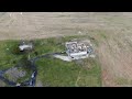
- Microburst and Hail Damage in Southern Marion County, Kentucky on May 18, 2022
- Date posted
- 4 years ago
- Description
- Drone survey of 97 mph microburst wind damage in southern Marion County, Kentucky. These winds destroyed a garage, moved a pickup truck 4 feet, and caused significant roof and tree damage. Ping pong ball size hail also occurred, causing significant siding damage.
---------------------------------
National Weather Service
Weather Forecast Office
Louisville, KY

- Title
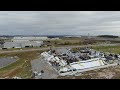
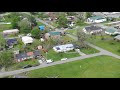
- Drone Survey of Tornado Damage 4/13/22 in southern Louisville, KY
- Date posted
- 4 years ago
- Description
- Drone video of tornado damage on 4/13/2022 in southern Louisville, KY.
---------------------------------
National Weather Service
Weather Forecast Office
Louisville, KY

- Title
- Tornado Damage 04/13/22 near Bardstown Road in southern Louisville Kentucky
- Date posted
- 4 years ago
- Description
- Tornado Damage 04/13/22 near Bardstown Road and Long Home Road in southern Louisville Kentucky
---------------------------------
National Weather Service
Weather Forecast Office
Louisville, KY

- Title
- NWS Louisville Briefing for Severe Weather April 13th, 2022
- Date posted
- 4 years ago
- Description
- Here's the latest timing and threat details for the severe weather expected across central Kentucky and south central Indiana tonight into the overnight.
---------------------------------
National Weather Service
Weather Forecast Office
Louisville, KY
- Title
- Tornado Damage in Hardin County (3/18-3/19, 2022 Storms)
- Date posted
- 4 years ago
- Description
- Drone footage of tornado damage in Hardin County, Kentucky, from storms that pushed through the overnight hours of March 18, 2022 into the early morning hours of March 19, 2022.
---------------------------------
National Weather Service
Weather Forecast Office
Louisville, KY

- Title
- NWS Louisville: Winter Weather Briefing 3/11/2022
- Date posted
- 4 years ago
- Description
- Here's the latest thinking for Kentucky and south-central Indiana on the winter storm tonight into Saturday morning. For the latest information, go to weather.gov/lmk/winter
---------------------------------
National Weather Service
Weather Forecast Office
Louisville, KY

- Title
- Looking back on March 2nd 2012 with Some of the Local Louisville Weather Media
- Date posted
- 4 years ago
- Description
- Got the perspective of some in the local Lousiville weather media about what the remember from March 2nd and the impact it had on them. We also asked how important that relationship is with the our office on big events like March 2, 2012.
---------------------------------
National Weather Service
Weather Forecast Office
Louisville, KY

- Title
- Conversation: Look Back on the March 2nd 2012 Outbreak with Meteorologist-In-Charge John Gordon
- Date posted
- 4 years ago
- Description
- Former WLKY/WHAS Meteorologist, now with the National Weather Service in Phoenix, Jared Heil, talks with National Weather Service Meteorologist-In-Charge John Gordon about the March 2nd 2012 Tornado Outbreak that hit Jared's hometown of Henryville, IN on March 2nd.
---------------------------------
National Weather Service
Weather Forecast Office
Louisville, KY

- Title
- National Weather Service Staff Looks Back on the Tenth Anniversary of March 2nd 2012
- Date posted
- 4 years ago
- Description
- Some of the National Weather Service Meteorologist look back and talk about their experience from March 2, 2012 on the Tenth Anniversary of the tornado outbreak.
---------------------------------
National Weather Service
Weather Forecast Office
Louisville, KY

- Title
- 25th Anniversary March 97 Flood - Perspective from local Louisville reporter who worked the flood
- Date posted
- 4 years ago
- Description
- We talk to WHAS-TV reporter/anchor Doug Proffitt who worked during the March Flood of 1997 25 years later. File footage courtesy WHAS-TV. Not for rebroadcast or other distribution.
---------------------------------
National Weather Service
Weather Forecast Office
Louisville, KY

- Title
- 25th Anniversary March '97 Flood - Perspective from a former NWS Louisville meteorologist
- Date posted
- 4 years ago
- Description
- Former National Weather Service Louisville Service Hydrologist tells his story from working during the March 1997 flood.
---------------------------------
National Weather Service
Weather Forecast Office
Louisville, KY

- Title
- 25th Anniversary March '97 Flood - Perspective from a forecaster at the Ohio River Forecast Center
- Date posted
- 4 years ago
- Description
- We talk to a forecaster from the Ohio River Forecast Center who worked during the March Flood of 1997, 25 years later.
---------------------------------
National Weather Service
Weather Forecast Office
Louisville, KY

- Title
- How to Find Your Hourly Forecast
- Date posted
- 4 years ago
- Description
- This video will guide you on how to find the latest NWS hour-by-hour forecast for your area.
---------------------------------
National Weather Service
Weather Forecast Office
Louisville, KY

- Title
- NWS Louisville Evening Winter Weather Briefing 2/1/2022
- Date posted
- 4 years ago
- Description
- Winter weather with significant impacts are expected Thursday into Friday. For the latest information, please visit www.weather.gov/lmk or www.weather.gov/lmk/winter.
---------------------------------
National Weather Service
Weather Forecast Office
Louisville, KY

- Title
- **This information is outdated** NWS Louisville Winter Weather Briefing 2/1/2022
- Date posted
- 4 years ago
- Description
- **This information is outdated. Please see our website for the latest updates on the winter storm**
Winter weather with significant impacts are expected Thursday into Friday. For the latest information, please visit www.weather.gov/lmk or www.weather.gov/lmk/winter.
---------------------------------
National Weather Service
Weather Forecast Office
Louisville, KY

- Title
- Weather Briefing Wed. Jan. 19, 2022 - Impactful snow and cold
- Date posted
- 4 years ago
- Description
- Wednesday afternoon update as of 3:30 pm EST on the snow and it's impact tonight into Thursday morning...
For the most up-to-date forecast and information visit http://weather.gov/louisville
---------------------------------
National Weather Service
Weather Forecast Office
Louisville, KY

- Title
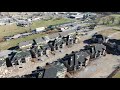
- Tornado Damage in Logan County (from January 1, 2022, storms)
- Date posted
- 4 years ago
- Description
- Video provides aerial views of damage to a barn and trees from an EF-1 tornado in Logan County on January 1, 2022.
---------------------------------
National Weather Service
Weather Forecast Office
Louisville, KY

- Title
- EF-1 Tornado damage from January 1, 2022, storms near Glasgow, KY
- Date posted
- 4 years ago
- Description
- A supercell thunderstorm produced a tornado in Barren County, KY, during the afternoon hours of January 1, 2022. The following video was taken 2 miles from Glasgow, KY, and features damage to a barn.
---------------------------------
National Weather Service
Weather Forecast Office
Louisville, KY
- Title
- Tornado damage over eastern Warren County from early AM December 11, 2021, storms
- Date posted
- 4 years ago
- Description
- As of December 16, 2021, storm survey crews are still assessing the damage and rating of this tornado.
---------------------------------
National Weather Service
Weather Forecast Office
Louisville, KY

- Title
- Tornado Damage from early morning December 11, 2021, storms in Bowling Green, Kentucky
- Date posted
- 4 years ago
- Description
- As of December 16, 2021, preliminary rating on storm damage is EF-3.
---------------------------------
National Weather Service
Weather Forecast Office
Louisville, KY

- Title
- Hart County Tornado Damage from early morning December 11, 2021, storms
- Date posted
- 4 years ago
- Description
- Preliminary surveys in Hart County revealed EF-2 Tornado Damage.
---------------------------------
National Weather Service
Weather Forecast Office
Louisville, KY

- Title
- Tornado Damage in Ohio County from early morning December 11, 2021, storms
- Date posted
- 4 years ago
- Description
- Preliminary surveys from Ohio County revealed EF-3 tornado damage.
---------------------------------
National Weather Service
Weather Forecast Office
Louisville, KY

- Title
- Preliminary EF-2 Damage in Western Bowling Green, KY (taken 12/14/21)
- Date posted
- 4 years ago
- Description
- EF-2 Damage in Bowling Green, Kentucky from 12/14/2021.
---------------------------------
National Weather Service
Weather Forecast Office
Louisville, KY

- Title
- Preliminary EF-2 Tornado Damage in Bowling Green (taken 12/13/21)
- Date posted
- 4 years ago
- Description
- A strong line of storms swept through Bowling Green, KY, during the early morning hours of Saturday, December 11th, 2021. NWS Survey teams are currently assessing the damage and have a preliminary rating of EF-2 for this tornado in Bowling Green, KY.
---------------------------------
National Weather Service
Weather Forecast Office
Louisville, KY

- Title
- View of Mayfield, Kentucky Supercell from Airplane Cockpit - December 10, 2021
- Date posted
- 4 years ago
- Description
- This video was taken at 45,000ft from the cockpit of an airplane looking at the storm that produced the tornado beginning in Arkansas, through Mayfield, KY, and so many other areas. Cloud tops on this storm were 47,000ft and rising.
Please contact NWS Louisville (@NWSLouisville on Twitter) for permission to use video.
---------------------------------
National Weather Service
Weather Forecast Office
Louisville, KY
- Title
- Preliminary EF-3 Tornado Damage in Bowling Green, KY (taken 12/12/21)
- Date posted
- 4 years ago
- Description
- A strong line of storms swept through Bowling Green, KY, during the early morning hours of Saturday, December 11th, 2021. NWS Survey teams are currently assessing the damage and have a preliminary rating of EF-3 for this tornado in Bowling Green, KY.
---------------------------------
National Weather Service
Weather Forecast Office
Louisville, KY

- Title
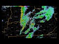
- Radar Loop of Tornado Outbreak December 10-11, 2021
- Date posted
- 4 years ago
- Description
- A wide view of the storms that moved across Kentucky and surrounding states during the night of December 10-11, 2021.
---------------------------------
National Weather Service
Weather Forecast Office
Louisville, KY
- Title
- Preliminary EF-3 Tornado Damage north of Saloma, KY (taken 12/12/21)
- Date posted
- 4 years ago
- Description
- A strong line of storms swept through Taylor County, KY, during the early morning hours of Saturday, December 11, 2021. These storms produced a strong tornado with a preliminary rating of EF-3 tornado damage north of Saloma, KY.
---------------------------------
National Weather Service
Weather Forecast Office
Louisville, KY

- Title
- Ring Doorbell footage of EF-1 Tornado north of Franklin, KY (12/6/21)
- Date posted
- 4 years ago
- Description
- During the pre-dawn hours of December 6, an EF-1 tornado struck portions of Franklin County just north of Frankfort, KY. Greg Tigges shared this footage he captured with his Ring doorbell camera as the tornado hit his property. NWS Louisville expresses their thanks to Greg for allowing us to display his video on our YouTube channel.
---------------------------------
National Weather Service
Weather Forecast Office
Louisville, KY

- Title
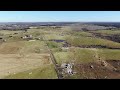
- EF-0 Tornado Damage Near Lexington, IN (10/15/21)
- Date posted
- 5 years ago
- Description
- Aerial views of tornado damage near Lexington, IN from an EF-0 tornado that struck the night of October 15, 2021.
---------------------------------
National Weather Service
Weather Forecast Office
Louisville, KY

- Title
- National Weather Service Louisville 150 Anniversary: Where we are Today and Going Tomorrow?
- Date posted
- 5 years ago
- Description
- The National Weather Service Office in Louisville, KY has covered a lot of ground over the last 150 years and there is still a lot for us to learn going into the future. Find out more about what we've been doing and what we are working on going into the future.
---------------------------------
National Weather Service
Weather Forecast Office
Louisville, KY

- Title
- National Weather Service Louisville 150 Anniversary: Some of Our Former Employees
- Date posted
- 5 years ago
- Description
- You got to hear from some of our partners and what the National Weather Service in Louisville has meant to them. But we couldn't do the work we do without the people, past and current, that make up our local National Weather Service Office. Here are just a few past employees to talk about their time here in our office.
---------------------------------
National Weather Service
Weather Forecast Office
Louisville, KY

- Title
- National Weather Service Louisville 150 Anniversary: More Congratulations from our Partners
- Date posted
- 5 years ago
- Description
- Along with the local media, the National Weather Service in Louisville works closely with our local and state governments during impactful weather events. We're also responsible for aviation weather out of Muhammad Ali International Airport, and other airports across central KY and southern IN. Education and research are also very vital to our mission and we do research with local schools and universities.
---------------------------------
National Weather Service
Weather Forecast Office
Louisville, KY

- Title
- National Weather Service Louisville 150 Anniversary: Relationship with Our Media Partners Part 2
- Date posted
- 5 years ago
- Description
- As we continue to celebrate our 150th Anniversary, we hear from more of our great local media partners from across central Kentucky. Without a strong working relationship with the local media, much of what we do here at the National Weather Service in Louisville would get out to the public. Want to thank Bill Meck at WLEX, Shane Holinde 13 News at WBKO, Chris Allen at SAM 100.7 WKLX and formerly WBKO and Jay Cardosi WLKY.
---------------------------------
National Weather Service
Weather Forecast Office
Louisville, KY

- Title
- National Weather Service Louisville 150 Anniversary: Relationship with Our Media Partners Part 1
- Date posted
- 5 years ago
- Description
- The mission of the National Weather Service is to protect life and property. This mission could not be achieved without the strong relation we have with our local media partners. Most life saving weather information might go unseen if not for that information being broadcast by local television and radio. Hear, in their own words, what this partnership means to them and their job as broadcast meteorologists.
---------------------------------
National Weather Service
Weather Forecast Office
Louisville, KY

- Title
- The National Weather Service in Louisville, KY Celebrates 150 Years of Service
- Date posted
- 5 years ago
- Description
- On September 11, 2021 the National Weather Service office in Louisville, KY celebrates its 150 anniversary serving the Louisville Area as well as central Kentucky and southern Indiana. We take you through brief history of our office and how it corresponds with the National Weather Service as a whole over those 150 years.
---------------------------------
National Weather Service
Weather Forecast Office
Louisville, KY

- Title
- Why have our sunrise/sunsets looked reddish-orange?
- Date posted
- 5 years ago
- Description
- Smoke is the reason we've seen a vivid reddish-orange sun at sunrise and sunset. We explain what gives the sun that color.
---------------------------------
National Weather Service
Weather Forecast Office
Louisville, KY
- Title
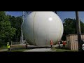
- NWS Louisville KLVX Service Life Extension Program 2021
- Date posted
- 5 years ago
- Description
- The Service Life Extension Program (SLEP) consists of 4 independent projects executed over the past 8 years. SLEP is meant to keep our weather radars functional beyond 2030 and involved replacing and refurbishing major components of weather radars.
KLVX radar, which serves the central Kentucky and southern IN region, underwent a new pedestal installment on July 15, 2021.
---------------------------------
National Weather Service
Weather Forecast Office
Louisville, KY

- Title
- F4 tornado strikes Bullitt County, KY, May 28, 1996
- Date posted
- 5 years ago
- Description
- A powerful tornado struck just south of Louisville, Kentucky. Bullitt County was hardest hit.
---------------------------------
National Weather Service
Weather Forecast Office
Louisville, KY
- Title
- EF-1 Tornado Damage in Tompkinsville, KY (5/3/21)
- Date posted
- 5 years ago
- Description
- Aerial views of tornado damage in Tompkinsville, KY, from an EF-1 tornado that struck the morning of May 3, 2021.
---------------------------------
National Weather Service
Weather Forecast Office
Louisville, KY
- Title
- March 25, 2021 Damaging Winds, Hail, and Tornadoes
- Date posted
- 5 years ago
- Description
- Radar animation showing the storms that produced hail, damaging winds, and three tornadoes across central Kentucky on March 25, 2021.
---------------------------------
National Weather Service
Weather Forecast Office
Louisville, KY

- Title
- Ground Swirls Left By EF-0 Tornado
- Date posted
- 5 years ago
- Description
- On the evening of March 25, 2021 an EF-0 tornado left these marks in an open field east of Clarkson, Kentucky.
---------------------------------
National Weather Service
Weather Forecast Office
Louisville, KY