NWS Duluth
NWS Duluth Skywarn Spotter Training 2024

- Title
- NWS Duluth Skywarn Spotter Training 2024
- Date posted
- 19 days ago
- Description
- The National Weather Service in Duluth, MN, presents the 2024 Skywarn Spotter Training. There are three "code words" in the video - write down each word then head to https://www.weather.gov/dlh/skywarn to register as a spotter for our office!
*This training is for our office's area, which covers northeast Minnesota and northwest Wisconsin. If you're from another part of the country, please contact your local office's Skywarn contact for information about becoming a spotter! https://www.weather.gov/skywarn/wfo_links
---------------------------------
National Weather Service
Weather Forecast Office
Duluth, MN
00:00 Intro
00:09 Instructor Introduction
02:03 Tornado Video
03:02 About the National Weather Service in Duluth, MN
04:38 What is a spotter?
06:37 Why do we need spotters?
13:49 Where to get the forecast? There are more sources than ever for weather information today
15:49 Staying ...

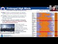
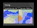
- Title
- January 2024 Mid-Winter Update
- Date posted
- 3 months ago
- Description
- A look at winter 2023-2024 so far, where we're at now, and what to expect for the rest of winter and early spring.
Recorded at 1:00 PM Saturday January 27, 2024.
---------------------------------
National Weather Service
Weather Forecast Office
Duluth, MN
- Title
- Thursday, December 22 Afternoon Winter Weather Update
- Date posted
- 1 year ago
- Description
- Here is a quick update regarding the hazard overhaul that we did earlier today and what is still expected for winter weather through the end of this week and into the weekend.
---------------------------------
National Weather Service
Weather Forecast Office
Duluth, MN
- Title
- 2022 NWS Duluth Winter Spotter Training
- Date posted
- 1 year ago
- Description
- This special winter-edition of spotter training covers winter weather safety, the science of winter weather, how to measure and report snow and ice, and ways to keep up-to-date on the forecast from the National Weather Service. We hope you enjoy it This video was produced in November 2022. (Note: Unlike our spring training, there is no certificate or registration process for this training - just sit back, watch, and enjoy!)
Handout Docs: https://www.weather.gov/dlh/winterspotter
0:00 - Intro
2:00 - Winter Weather Safety
11:19 - Winter Weather Science
28:25 - Measuring and Reporting Winter Weather
39:23 - Keeping up with the Forecast
---------------------------------
National Weather Service
Weather Forecast Office
Duluth, MN

- Title
- New Nearshore Marine Zone In The Apostle Islands
- Date posted
- 3 years ago
- Description
- The National Weather Service in Duluth, MN recently added a new nearshore marine zone within the Apostle Islands archipelago. This change is intended to improved our marine services around the Apostle Islands.
For more information on this change, visit: https://www.weather.gov/dlh/apostle-islands-marine-zone-change
To view our nearshore forecast and other Great Lakes marine products, visit:
https://www.weather.gov/greatlakes/
---------------------------------
National Weather Service
Weather Forecast Office
Duluth, MN
weather.gov/duluth
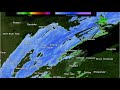
- Title
- December 23-24, 2020 Winter Storm/Blizzard Radar Loop
- Date posted
- 3 years ago
- Description
- A radar loop from the December 23-24, 2020 Winter Storm/Blizzard. (No Audio.)
This video shows the MRMS radar composite, color-coded by precipitation type (blues for snow, greens for rain) where darker colors mean more intense precipitation. Note that due to MRMS included Canadian radar, the the Canadian radar near Thunder Bay "overrules" the Duluth radar, hence why there is much different looking radar across the tip of the Minnesota Arrowhead. This is just a radar artifact from merging these two different radar networks. Also note the rain/snow coloring is just an estimated based on model data - in reality there was a mix of precipitation including rain, sleet, and snow depending on precipitation rates before precipitation changed over to all snow.
For more information about this storm visit our storm summary page at https://www.weather.gov/dlh/2020-12-23-Northland-Blizzard
---------------------------------
National Weather Service

- Title
- 2020 Winter Spotter Training
- Date posted
- 3 years ago
- Description
- This special winter-edition of spotter training covers winter weather safety, the science of winter weather, how to measure and report snow and ice, and ways to keep up-to-date on the forecast from the National Weather Service. We hope you enjoy it! (Note: Unlike our spring training, there is no certificate or registration process for this training - just sit back, watch, and enjoy!)
Handout Docs: https://www.weather.gov/dlh/winterspotter2020
0:00 - Intro
2:56 - Winter Weather Safety
8:56 - Winter Weather Science
26:04 - Measuring and Reporting Winter Weather
42:43 - Keeping up with the Forecast
---------------------------------
National Weather Service
Weather Forecast Office
Duluth, MN
- Title
- M/V Stewart J. Cort from KDLH WSR-88D August 10, 2019
- Date posted
- 5 years ago
- Description
- The M/V Stewart J. Cort appeared on the KDLH WSR-88D during the morning hours of August 10, 2019 between 6:20 AM CDT and 8:43 AM CDT. This is not the first time a lake boat was observed by our radar. This phenomena is caused by "super refraction" of our radar beam causing it to bend closer to the surface of the earth than otherwise expected.
Super refraction is the result of the radar beam passing through a very stable airmass compared to the "standard atmosphere". It can also occur when warm moist air is advected over a cool surface, like Lake Superior.
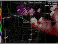
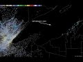
- Title
- Kennan-Ogema Tornado, June 14, 2019, Storm-relative Velocity Loop
- Date posted
- 5 years ago
- Description
- A tornado struck southern Price County, WI during the evening of June 14, 2019 and moved from west-northwest of Kennan to west of Ogema. This video is a radar loop of the storm which produced the tornado along with an approximate path of the tornado.
This tornado was produced by a low-topped supercell and occurred at a range around 100 to 120 miles from the Duluth WSR-88D. At that range, the radar was only able to sample the top half of the storm. All of the low-level features which would help identify this storm as a tornado producer were below the lowest scan elevation.
The loop of storm-relative velocity starts at 6:26 PM CDT, approximately half an hour before the tornado touched down and ends at 8:03 PM CDT, approximately half an hour after the tornado lifted.
View a loop of reflectivity from this storm at https://youtu.be/JiAmI64038k.
---------------------------------
National Weather Service
Weather Forecast Office
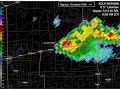
- Title
- Kennan-Ogema Tornado, June 14, 2019, Reflectivity Loop
- Date posted
- 5 years ago
- Description
- A tornado struck southern Price County, WI during the evening of June 14, 2019 and moved from west-northwest of Kennan to west of Ogema. This video is a radar loop of the storm which produced the tornado along with an approximate path of the tornado.
This tornado was produced by a low-topped supercell and occurred at a range around 100 to 120 miles from the Duluth WSR-88D. At that range, the radar was only able to sample the top half of the storm. All of the low-level features which would help identify this storm as a tornado producer were below the lowest scan elevation.
The loop of radar reflectivity starts at 6:26 PM CDT, approximately half an hour before the tornado touched down and ends at 8:03 PM CDT, approximately half an hour after the tornado lifted.
View a loop of storm-relative velocity from this storm at https://youtu.be/g11lFiBipF0.
---------------------------------
National Weather Service
Weather Forecast Of...

- Title
- The Radiosonde
- Date posted
- 9 years ago
- Description
- Information about the NWS radiosonde program with added information for the school weather balloon launches.

- Title
- August 22, 2015 Severe Weather Briefing
- Date posted
- 9 years ago
- Description
- This is a video briefing produced on Aug 22, 2015 at just before noon covering the threat for severe thunderstorms today across northeast Minnesota and northwest Wisconsin. Please visit our website for the latest details at http://weather.gov/duluth
---------------------------------
National Weather Service
Weather Forecast Office
Duluth, MN

- Title
- What's A Wall Cloud?
- Date posted
- 9 years ago
- Description
- Learn about wall clouds; what they are, how they form and what could make them very dangerous.

- Title
- SPOT Request Training
- Date posted
- 9 years ago
- Description
- SPOT Forecast Request and Monitor Website Tutorial
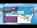
- Title
- January 2, 2015 Evening Winter Weather Briefing
- Date posted
- 9 years ago
- Description
- A fast-moving clipper will bring snow to northern Minnesota and northwest Wisconsin tonight through Saturday night. Snow will be heavy at times along the International Border late tonight through Saturday afternoon, with 6 to 11 inches of snow possible in Koochiching and Northern St. Louis Counties. A band of 3 to 6 inches will be found just south of the heavier band, with less than 3 inches expected generally south of MN-200 and US-2. Travel may become difficult late tonight and Saturday generally north of US_MN-169 and MN-1. Lake enhancement may increase snow totals in the Arrowhead and over portions of northwest Wisconsin. Winter storm warnings and advisories have been posted for portions of north-central and northeast Minnesota. Additional snowfall is possible in northwest Wisconsin on Monday and Monday night. Behind the departing low Saturday night through Wednesday, bitterly cold air and dangerous wind chills are expected. Wind chills advisories and warnings will likely be needed...

- Title
- mPING
- Date posted
- 9 years ago
- Description
- Be a citizen scientist. Report weather types via the mPING interface using your GPS device.

- Title
- mPING
- Date posted
- 10 years ago
- Description
- describes how people can use the mPING app on their smart phones to report weather types at their locations.
- Title
- Default MMWB video
- Date posted
- 10 years ago
- Description
- A video about the services that NWS Duluth provides through YouTube.

- Title
- Fire Weather Planning Forecast Changes
- Date posted
- 10 years ago
- Description
- This 7 min presentation is a summary of changes implemented this season the Fire Weather Planning Forecast. These changes only effect a portion of the Fire-Weather Zones in the Duluth National Weather Service Forecast Area.