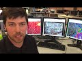
NWS Twin Cities
The Twin Cities National Weather Service wants your severe weather pictures!
- Title
- The Twin Cities National Weather Service wants your severe weather pictures!
- Date posted
- 8 years ago
- Description
- Sharing your severe weather pictures on social media is a great way to keep your community informed and helps meteorologists at the National Weather Service verify radar information. Tweet your pictures @NWSTwinCities and visit facebook.com/NWSTwinCities
Take your love for storms to the next level - become a Skywarn Spotter! skywarn.org. Storm ID guidebook: nws.noaa.gov/os/brochures/SGJune6-11.pdf
- Title
- Infrared Satellite Loop June 17th
- Date posted
- 8 years ago
- Description
- A loop of infrared satellite imagery for storms that moved across western MN on the afternoon and evening of June 17th.
---------------------------------
National Weather Service
Weather Forecast Office
Twin Cities/Chanhassen, MN
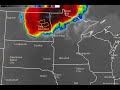
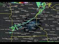
- Title
- Radar loop of severe thunderstorms on June 17, 2016
- Date posted
- 8 years ago
- Description
- Radar loop for severe storms on June 17, 2016 with warnings issued.
---------------------------------
National Weather Service
Weather Forecast Office
Twin Cities/Chanhassen, MN
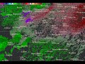
- Title
- Radar velocity imagery loop of downburst developing over Le Sueur county.
- Date posted
- 8 years ago
- Description
- In this loop of velocity images from MPX, you can see the development of a divergent wind signature over Le Sueur county to the south of Montgomery that was associated with a severe downburst in its early stages. This downburst would go on to produce a 75 mph wind gust south of Cannon Falls.
---------------------------------
National Weather Service
Weather Forecast Office
Twin Cities/Chanhassen, MN
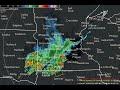
- Title
- Radar Loop of Severe Storms June 10, 2016
- Date posted
- 8 years ago
- Description
- During the afternoon of June 10, 2016 a line of severe thunderstorms developed from southern Minnesota into western WI. These storm worked across WI through the evening before dissipating over northern lower Michigan Friday night. The strongest observed wind gust with this line in MN was 75 mph from MNDOT sensors along I-35 at the Iowa border and along US-52 south of Cannon Falls.
---------------------------------
National Weather Service
Weather Forecast Office
Twin Cities/Chanhassen, MN

- Title
- 40 MPH gusts with the cold front
- Date posted
- 8 years ago
- Description
- 40 MPH wind gusts were observed with the passage of the cold front in Chanhassen early this morning (April 2nd, 2016).
---------------------------------
National Weather Service
Weather Forecast Office
Twin Cities/Chanhassen, MN
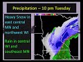
- Title
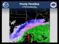
- March 23, 2016 Snowstorm Briefing
- Date posted
- 8 years ago
- Description
- This short video provides some insight into the snowstorm Wednesday and Wednesday night. The main takeaway is there will be a very sharp snowfall gradient across Minnesota and Wisconsin but confidence is low with where it will set up. Confidence is high, however, that 6-12+ inches will fall within the band of heavy snow.
---------------------------------
National Weather Service
Weather Forecast Office
Twin Cities/Chanhassen, MN
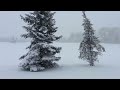
- Title
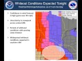
- Ground blizzard expected tonight, Feb 07 2016
- Date posted
- 8 years ago
- Description
- Winds will increase and cause whiteout conditions across southern Minnesota.
---------------------------------
National Weather Service
Weather Forecast Office
Twin Cities/Chanhassen, MN
- Title
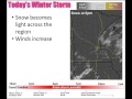
- Decision Support Briefing - Winter Storm Feb 02
- Date posted
- 8 years ago
- Description
- DSS video highlighting the timing of the snow and wind
---------------------------------
National Weather Service
Weather Forecast Office
Twin Cities/Chanhassen, MN
- Title
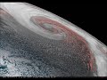
- Intense Bering Sea Storm
- Date posted
- 9 years ago
- Description
- Amazing satellite loop from Himawari-8 of the intense storm currently in the Bering Sea

- Title
- StormReady in a Box
- Date posted
- 9 years ago
- Description
- The National Weather Service Twin Cities is proud to announce the creation of a new way for area schools to become StormReady! Throughout the summer, the StormReady in a Box concept was derived by one of our student interns with help from scientists, local educators, and school safety experts. StormReady in a Box is a project, designed for teachers and students, to help their school earn StormReady Supporter status from the National Weather Service. Everything you need to do the project is provided for you and we will be able to help you every step of the way. Contact us at 952-361-6671 or w-mpx.webmaster@noaa.gov to get started right away!
---------------------------------
National Weather Service
Weather Forecast Office
Twin Cities/Chanhassen, MN
- Title
- May 6, 1965 MSP Radar Loop - Full Length Version
- Date posted
- 9 years ago
- Description
- May 6, 1965 MSP Radar Loop - Full Length Version.
This is from the original film produced by the WSR-57 radar located at the Minneapolis-St. Paul International Airport. The radar imagery shows several supercell thunderstorms that produced 6 strong tornadoes on May 6, 1965 in and around the Twin Cities metro area. A special thanks to Alyson Jubert of Eyetography and Jim du Bois, the president and CEO of the Minnesota Broadcasters Association for the creation of this video that was made from the original National Weather Service film. Special thanks also to Dan Miller, Science and Operations Officer at Portland, OR (and formerly the SOO at NWS Duluth MN) for retrieving the video, taking special care to preserve it, analysis, and presentations.

- Title
- Original radar from the 1965 Twin Cities Tornado Outbreak
- Date posted
- 9 years ago
- Description
- This is a short video created from the original film produced by the WSR-57 radar located at the Minneapolis-St. Paul International Airport. The radar imagery shows several supercell thunderstorms that produced 6 strong tornadoes on May 6, 1965 in and around the Twin Cities metro area. A special thanks to Alyson Jubert of Eyetography and Jim du Bois, the president and CEO of the Minnesota Broadcasters Association for the creation of this video that was made from the original National Weather Service film. Special thanks also to Dan Miller, Science and Operations Officer at Portland, OR (and formerly the SOO at NWS Duluth MN) for retrieving the video, taking special care to preserve it, analysis, and presentations.
---------------------------------
National Weather Service
Weather Forecast Office
Twin Cities/Chanhassen, MN

- Title
- Meet the National Weather Service - Twin Cities, MN
- Date posted
- 9 years ago
- Description
- We are the NWS Twin Cities. Our mission is to protect life and property by providing weather warnings and information to the general public.
---------------------------------
National Weather Service
Weather Forecast Office
Twin Cities/Chanhassen, MN
- Title
- Radar Training: Part1
- Date posted
- 9 years ago
- Description
- Basic overview of radar using GR Analyst
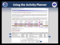
- Title
- Navigating Our Web site - Activity Planner
- Date posted
- 9 years ago
- Description
- A short tutorial describing how to use our Activity planner.
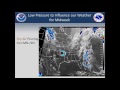
- Title
- Surface Low Pressure and Stability
- Date posted
- 10 years ago
- Description
- Explains why storms intensify.

- Title
- Fog Burning Off - Sunday Morning, June 8, 2014
- Date posted
- 10 years ago
- Description
- Satellite view of fog in the Minnesota and St. Croix River Valleys burning off between 715 AM and 915 AM.
- Title
- Mesolow and Ice on Lake Michigan - February 16, 2014
- Date posted
- 10 years ago
- Description
- This fast satellite loop shows a small area of low pressure (mesolow) dropping south over Lake Michigan today. Ice movement can also be seen, particularly over the eastern and northern part of the Lake.
- Title
- Interesting Phenomena Occurring In Central Minnesota Today
- Date posted
- 10 years ago
- Description
- An interesting phenomena occurred today in central Minnesota. Do you know what it is?
Here is the answer to our earlier question for anyone who may have missed our response on the original thread:
The infrared satellite is picking up the heat associated with the abundant steam coming from the Sherco Generating Station (also commonly referred to as the Becker Power Plant or Monticello Power Plant)
Those of you near that area are familiar with the thick clouds of steam it produces, especially on an extremely cold day like today. In the past, the heat/steam has even produced light snow showers in the area, including over I-94.

- Title
- Coldest Weather Balloon Launch in Years at NWS Twin Cities - January 6, 2014
- Date posted
- 10 years ago
- Description
- The temperature was -24 and a wind chill around -45 as the balloon was launched on the morning of January 6, 2014. Weather balloons collect data throughout the entire atmosphere and are launched twice a day.
---------------------------------
National Weather Service
Weather Forecast Office
Twin Cities/Chanhassen, MN

- Title
- NWS Cold Weather Experiment
- Date posted
- 11 years ago
- Description
- The temperature was -16 F at the NWS office around sunrise this morning, so we quickly took the water from the coffee maker and threw it into the crisp December air. The water quickly evaporated due to the large temperature difference from the hot water droplets and the cold air. The newly added moisture in the form of water vapor then almost instantly saturates the air and we start to deposit ice crystals. So, the sequence is liquid - gas - solid, and it occurs almost instantly.
---------------------------------
National Weather Service
Weather Forecast Office
Twin Cities/Chanhassen, MN
- Title
- Lake Effect Clouds Moving South From Lake Winnipeg and Lake Manitoba
- Date posted
- 11 years ago
- Description
- When the sun rose this morning, it became obvious the low clouds moving into Minnesota were caused by very cold air moving over the relatively warm water of Lake Winnipeg and Lake Manitoba. The air temperature at the surface near both lakes ranged from about -5 to 10 degrees, and the water temperature of both lakes was in the mid 30s.

- Title
- Wind Chill 2001 - Wind Tunnel Tests on People
- Date posted
- 11 years ago
- Description
- A short clip taken from a video describing how the wind chill was revised in 2001, including people walking on treadmills in a controlled windy and cold environment. Frostbite times were also determined. Before this, the wind chill formula used by the NWS was one derived in Antarctica in the 1940s but never tested on people. The NWS teamed with Environment Canada to do some testing and come up with more accurate wind chill numbers. The wind chill chart and calculator are here: http://www.nws.noaa.gov/om/windchill/index.shtml
---------------------------------
National Weather Service
Weather Forecast Office
Twin Cities/Chanhassen, MN
- Title
- How Fast Can the Sun Heat a Car?
- Date posted
- 11 years ago
- Description
- The sun's shortwave radiation heats objects that it strikes. For example, a dark dashboard or seat can easily reach temperatures in the range of 180 to over 200°F. These objects (e.g., dashboard, steering wheel, child seat) heat the adjacent air by conduction and convection and also give off longwave radiation which is very efficient at warming the air trapped inside a vehicle.
Shown are time lapse photos of thermometer readings in a car over a period of less than an hour. As the animation shows, in just over 2 minutes the car went from a safe temperature to an unsafe temperature of 94.3°F. This demonstration shows just how quickly a vehicle can become a death trap for a child.
Learn more at http://www.crh.noaa.gov/lmk/?n=noaaexcessiveheat#car
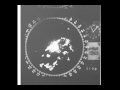
- Title
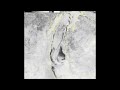
- Intriguing Radar Feature - Do you know what it is?
- Date posted
- 11 years ago
- Description
- This radar loop is from August 10, 2013 beginning at 1030pm and ending at 430am. It is from the Terminal Doppler Weather Radar, which is located to the northeast and not shown in the image. The top images are reflectivity, and the bottom images are velocity. The left hand images are at an elevation of 1300 feet above ground level in a standard atmosphere, and the right hand images are 3100 feet above ground level. There is an interesting feature being detected by radar in Scott County just to the west of Prior Lake, MN. The two top reflectivity images show a nearly stationary area of higher reflectivity values that quickly dissipates into a ring early this morning. The velocity image indicates a clockwise motion to the feature before it spreads out when the feature disappears.
---------------------------------
National Weather Service
Weather Forecast Office
Twin Cities/Chanhassen, MN
- Title
- Aug1, 2013 Weather Briefing
- Date posted
- 11 years ago
- Description
- Weather briefing for the next several days
- Title
- 2013 July1st Time Lapse of Shower Outflow
- Date posted
- 11 years ago
- Description
- Two hour time lapse of base reflectivity using the 1min data off the TDWR

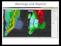
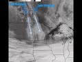
- Title
- Radar Loops from June 21, 2013 Severe Weather Event
- Date posted
- 11 years ago
- Description
- This a base reflectivity and base velocity loop taken from the NWS radar in Chanhassen, MN. The radar loop shows the complex of thunderstorms that tracked across the state of Minnesota and produced widespread tree damage.
---------------------------------
National Weather Service
Weather Forecast Office
Twin Cities/Chanhassen, MN

- Title
- Lightning Strike at National Weather Service Chanhassen, MN
- Date posted
- 11 years ago
- Description
- When thunder roars, go indoors! A video of a lightning strike on May 29, 2013 at the National Weather Service office in Chanhassen, Minnesota.
---------------------------------
National Weather Service
Weather Forecast Office
Twin Cities/Chanhassen, MN
- Title
- Multimedia Weather Briefing - May 23, 2013
- Date posted
- 11 years ago
- Description
- General Weather and Severe Weather Potential during the next several days.
- Title
- Snow melt April 23 2013
- Date posted
- 11 years ago
- Description
- This is a time lapse of visible satellite imagery of snow melt on April 23, 2013.
- Title
- 2013 April 22nd Hazardous Weather Briefing
- Date posted
- 11 years ago
- Description
- Overview of Winter Storm on April 22 2013
- Title
- Snowfall with seen at 9 am 4/11/13 at NWS Twin Cities
- Date posted
- 11 years ago
- Description
- Impressive snow fall rates have been seen with the ongoing winter storm with 1 to 2 inch per hour at times and even some thundersnow. This is the southern band as the main area lifted north.
---------------------------------
National Weather Service
Weather Forecast Office
Twin Cities/Chanhassen, MN
- Title
- What is concrete frost and how could it impact the MN and WI 2013 Spring Thaw
- Date posted
- 11 years ago
- Description
- Overview of Concrete Frost, where it exists in WI and MN and the potential impacts with the 2013 Spring Melt.
- Title
- Multi-Media Hazardous Weather Briefing - February 21st, 2013
- Date posted
- 11 years ago
- Description
- Multi-Media Hazardous Weather Briefing concerning the winter storm that will impact the region Thursday night and Friday