NWS Sioux Falls
Radar Loop - May 15, 2017

- Title
- Radar Loop - May 15, 2017
- Date posted
- 8 years ago
- Description
- 80 mph winds produce damage in Armour, South Dakota
Overview
A cluster of severe thunderstorms with winds of 60 to 80 mph moved through south central South Dakota between 8 and 9 AM CDT on May 15, 2017. Wind gusts up 80 mph caused damage to trees and few buildings in Armour, South Dakota. There was also a recorded wind gust of 72 mph north of Armour. Damage was also reported in Parkston, South Dakota where a 63 mph wind gust was recorded with these storms at 830 AM CDT. A storm survey was done by the NWS Sioux Falls this morning.
---------------------------------
National Weather Service
Weather Forecast Office
Sioux Falls, SD

- Title
- Regional Satellite View - June 11, 2017
- Date posted
- 8 years ago
- Description
- Overview - June 11, 2017
A complex of thunderstorm developed early Sunday morning and moved quickly across eastern South Dakota and western Minnesota. These storms produced large hail and damaging wind gusts as they moved through. The largest hailstone reported was nearly 2.5" in Slayton, MN. Winds greater than 60 mph were reported along with the hail in many cases.
This thunderstorm complex brought much needed rainfall to portions of the region. The highest totals were reported up to 2" near Huron, SD With fairly widespread 0.5-2" totals where thunderstorms tracked.
---------------------------------
National Weather Service
Weather Forecast Office
Sioux Falls, SD

- Title
- Regional Radar Loop - June 11, 2017
- Date posted
- 8 years ago
- Description
- Overview - June 11, 2016
A complex of thunderstorm developed early Sunday morning and moved quickly across eastern South Dakota and western Minnesota. These storms produced large hail and damaging wind gusts as they moved through. The largest hailstone reported was nearly 2.5" in Slayton, MN. Winds greater than 60 mph were reported along with the hail in many cases.
This thunderstorm complex brought much needed rainfall to portions of the region. The highest totals were reported up to 2" near Huron, SD With fairly widespread 0.5-2" totals where thunderstorms tracked.
---------------------------------
National Weather Service
Weather Forecast Office
Sioux Falls, SD

- Title
- Strong winds bring damage to northwestern Iowa - May 16, 2017
- Date posted
- 8 years ago
- Description
- An area of weakening thunderstorms produced a heat burst which resulted in 40-80 mph winds and temperatures warming to around 80 degrees.
---------------------------------
National Weather Service
Weather Forecast Office
Sioux Falls, SD

- Title
- Radar Loop for Severe Storms on June 29, 2017
- Date posted
- 8 years ago
- Description
- Severe thunderstorms developed along the Missouri River Valley and northwest Iowa during the afternoon of June 29, 2017. These storms produced large hail, damaging winds from 60 to 85 mph. The strongest wind gust was reported at Yankon Airport with 82 mph. The largest hail reported was softball size (4.5") near Sergeant Bluff, Iowa. There were two brief tornadoes south of the Missouri River in Nebraska. Also, funnel clouds were reported around the Sioux City area.
For more details see our Summary Severe Storms on June 29, 2017: http://www.weather.gov/fsd/20170629-severe
---------------------------------
National Weather Service
Weather Forecast Office
Sioux Falls, SD

- Title
- Picnics & Lightning Safety - Spanish Version
- Date posted
- 10 years ago
- Description
- National Weather Service Meteorologist Janice Maldonado discusses picnics and lightning safety in Spanish.
---------------------------------
National Weather Service
Weather Forecast Office
Sioux Falls, SD

- Title
- Difference between a Watch & a Warning - Spanish Version
- Date posted
- 10 years ago
- Description
- National Weather Service Meteorologist Janice Maldonado discusses the differences between watches & warnings in Spanish.
---------------------------------
National Weather Service
Weather Forecast Office
Sioux Falls, SD

- Title
- Difference between a Watch & a Warning
- Date posted
- 10 years ago
- Description
- Warning Coordination Meteorologist, Todd Heitkamp, of the National Weather Service office in Sioux Falls, discusses the differences between watches and warnings.

- Title
- Baseball & Lightning
- Date posted
- 10 years ago
- Description
- Warning Coordination Meteorologist, Todd Heitkamp, discusses what to do when at the ball field and threatening weather moves in!.

- Title
- Picnics & Lightning Safety - English Version
- Date posted
- 10 years ago
- Description
- National Weather Service Sioux Falls' Warning Coordination Meteorologist, Todd Heitkamp, discusses seeking shelter when being threatened by lightning while having a picnic.
---------------------------------
National Weather Service
Weather Forecast Office
Sioux Falls, SD

- Title
- Severe Reports from May 25, 2016
- Date posted
- 10 years ago
- Description
- Here is a radar loop of the storms that swept through part of the region on the evening of May 25th. Several reports of hail, high wind gusts, and wind damage were received.
---------------------------------
National Weather Service
Weather Forecast Office
Sioux Falls, SD

- Title
- EDIT: Radar loop of severe thunderstorms on April 24, 2016
- Date posted
- 10 years ago
- Description
- This is a radar loop of severe thunderstorms on April 24, 2016. These storms brought large hail and damagings to portions of northwestern Iowa. Heavy rain also fell over portions of southeast South Dakota including the southeast side of Sioux Falls.
---------------------------------
National Weather Service
Weather Forecast Office
Sioux Falls, SD

- Title
- Falls Park, Sioux Falls, SD on June 16 2004
- Date posted
- 11 years ago
- Description
- A short video is also available displaying the power and roar of the Falls on June 16 2004. At the Sioux Falls airport, over 2 inches of rain was observed in one hour, with multiple locations around the city receiving in excess of 3 inches of rain in 2 hours. The highest rainfall amount reported in Sioux Falls was 7.79 inches, with numerous reports of 3 to 6 inches across the city.
For details, see: http://weather.gov/fsd/2004-heavyrain-sd
---------------------------------
National Weather Service
Weather Forecast Office
Sioux Falls, SD

- Title
- Adam Thielen of the Minnesota Vikings discusses Winter Weather safety (30 sec.)
- Date posted
- 12 years ago
- Description
- In cooperation with the National Weather Service, Minnesota Viking's
Wide Receiver & ex-Minnesota State University Star, Adam Thielen,
discusses proper winter weather safety in this 30 second Public Service

- Title
- Adam Thielen of the Minnesota Vikings discusses Winter Weather safety
- Date posted
- 12 years ago
- Description
- In cooperation with the National Weather Service, Minnesota Viking's
Wide Receiver & ex-Minnesota State University Star, Adam Thielen,
discusses proper winter weather safety in this 15 second Public Service
Announcement.

- Title
- John Sullivan of the Minnesota Vikings discusses how you can be prepared this winter!
- Date posted
- 12 years ago
- Description
- In cooperation with the National Weather Service, Minnesota Viking's
center John Sullivan, discusses how you can be better prepared for this
winter season.

- Title
- John Sullivan of the Minnesota Vikings discusses Winter Weather safety
- Date posted
- 12 years ago
- Description
- In cooperation with the National Weather Service, Minnesota Viking's
center John Sullivan, discusses proper winter weather safety in a 15
second Public Service Announcement.

- Title
- Memories of 1994 CFC Campaign
- Date posted
- 12 years ago
- Description
- The Fall of 1994 saw "then" MIC Greg Harmon take a pie or two in the face as part of the office's Combined Federal Campaign in support of the United Way.
---------------------------------
National Weather Service
Weather Forecast Office
Sioux Falls, SD

- Title
- Todd Heitkamp takes the Ice Bucket Challenge
- Date posted
- 12 years ago
- Description
- Todd Heitkamp, the WCM for the National Weather Service in Sioux Falls, accepted the Ice Bucket Challenge from KDLT Meteorologist Brandon Spinner. Todd then challenged others!
---------------------------------
National Weather Service
Weather Forecast Office
Sioux Falls, SD

- Title
- Severe Weather Threat Along and East of I-29 on May 8
- Date posted
- 12 years ago
- Description
- There is a risk for severe thunderstorms from mid afternoon into early this evening along and east of Interstate 29. The greatest threat will be along and east of Highway 59 in southwest Minnesota and northwest Iowa.
---------------------------------
National Weather Service
Weather Forecast Office
Sioux Falls, SD

- Title
- Brief EF-0 Tornado in Lyon County, MN
- Date posted
- 12 years ago
- Description
- This video was provided by the Lyon County (MN) Office of Emergency Management. This brief EF-0 tornado was responsible for damage to a few farm out-buildings between Minneota and St. Leo on Monday, March 31st.
---------------------------------
National Weather Service
Weather Forecast Office
Sioux Falls, SD
- Title
- Strong winds expected with blizzard conditions north of I-90
- Date posted
- 12 years ago
- Description
- Strong winds will develop late tonight and continue into Thursday evening. Wind of 35 to 45 mph with gusts over 60 mph are expected across southeast South Dakota, southwest Minnesota, northwest Iowa and northeast Nebraska. In addition, 1 to 2 inches of snow is expected across east central South Dakota and southwest Minnesota creating blizzard conditions in areas north of Interstate 90.
---------------------------------
National Weather Service
Weather Forecast Office
Sioux Falls, SD

- Title
- Dangerous arctic air mass expected through Tuesday morning
- Date posted
- 13 years ago
- Description
- Dangerously cold wind chills from -35 to -60 are expected across the area through early Tuesday morning. The most severe conditions will be from this evening through Monday morning.
---------------------------------
National Weather Service
Weather Forecast Office
Sioux Falls, SD

- Title
- Dangerous Arctic Outbreak Expected Today through Tuesday morning
- Date posted
- 13 years ago
- Description
- A strong arctic front will move through the Northern Plains today bringing the coldest air of the season. Subzero cold combined with northwest gusting over 30 mph from this afternoon through Monday will result in wind chills from -40 to -60.
---------------------------------
National Weather Service
Weather Forecast Office
Sioux Falls, SD

- Title
- Dangerous Arctic Outbreak Expect From Sunday Through Tuesday
- Date posted
- 13 years ago
- Description
- A dangerously cold arctic air outbreak will move into the Northern Plains on Sunday and remain through Tuesday. The coldest air will be over the area Sunday night and Monday morning when wind chills of -40 to -60 are expected.
---------------------------------
National Weather Service
Weather Forecast Office
Sioux Falls, SD

- Title
- July 2, 2013 Thunderstorm Outflow Anontated
- Date posted
- 13 years ago
- Description
- Thunderstorm Outflow explained from July 2, 2013
National Weather Service
Weather Forecast Office
Sioux Falls, SD

- Title
- EDIT: What/When/Where (e.g. Strong Cold Front Moving Through Saturday)
- Date posted
- 13 years ago
- Description
- EDIT: Provide a short description describing the content of the video. Leave the "signature" below in every video.
---------------------------------
National Weather Service
Weather Forecast Office
Sioux Falls, SD

- Title
- An Update on the Extreme Cold Impacting the Tri-State Area
- Date posted
- 13 years ago
- Description
- Warning Coordination Meteorologist, Todd Heitkamp, provides an update on the extreme cold weather impacting the Tri-State area.
---------------------------------
National Weather Service
Weather Forecast Office
Sioux Falls, SD

- Title
- Afternoon update on the Winter Storm & Expecting Bitter Cold
- Date posted
- 13 years ago
- Description
- Todd Heitkamp, of the NWS office in Sioux Falls, provides an update on the winter storm affecting the Tri-State area and looks ahead to the expected bitter cold temperatures.
---------------------------------
National Weather Service
Weather Forecast Office
Sioux Falls, SD

- Title
- The latest on the Winter Storm affecting the Tri State Area
- Date posted
- 13 years ago
- Description
- The National Weather Service office in Sioux Falls provides the latest forecast on the winter storm affecting the Tri-State area.
---------------------------------
National Weather Service
Weather Forecast Office
Sioux Falls, SD

- Title
- Winter Storm & Cold to affect the Tri-State Area Beginning Tonight (12/3/13)
- Date posted
- 13 years ago
- Description
- NWS Sioux Falls provides the latest forecast on the winter storm to affect the Tri State area tonight through Wednesday.
---------------------------------
National Weather Service
Weather Forecast Office
Sioux Falls, SD
- Title
- Briefing on Severe Weather Threat for October 4
- Date posted
- 13 years ago
- Description
- A webcast discussing the severe weather threat for the late afternoon and evening of Friday, October 4.
---------------------------------
National Weather Service
Weather Forecast Office
Sioux Falls, SD
- Title
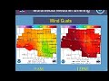
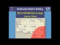
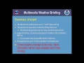
- Multimedia Weather Briefing for the Severe Weather Threat on October 4, 2013
- Date posted
- 13 years ago
- Description
- There is the possibility of isolated tornadoes, large hail and damaging winds Friday, October 4 over portions of northwestern Iowa, southeastern South Dakota, southwestern Minnesota and northeastern Nebraska.
---------------------------------
National Weather Service
Weather Forecast Office
Sioux Falls, SD

- Title
- A funny look inside NWS Sioux Falls!
- Date posted
- 13 years ago
- Description
- Warning Coordination Meteorologist Todd Heitkamp and some of the staff at NWS Sioux Falls show what they use to help write a weather forecast.
---------------------------------
National Weather Service
Weather Forecast Office
Sioux Falls, SD

- Title
- July 2, 2013 Thunderstorm Outflow
- Date posted
- 13 years ago
- Description
- 7.5 hour loop of thunderstorm outflow captured by Sioux Falls radar.

- Title
- Demonstration of the effects of the Cold!
- Date posted
- 13 years ago
- Description
- Todd Heitkamp, Warning Coordination Meteorologist for the National Weather Service in Sioux Falls, uses weather experiments to demonstrate the affects of the cold temperatures!
---------------------------------
National Weather Service
Weather Forecast Office
Sioux Falls, SD

- Title
- What's inside that Radar Dome?
- Date posted
- 13 years ago
- Description
- NWS Sioux Falls Warning Coordination Meteorologist, Todd Heitkamp, provides a look inside of the NWS Radar Dome.
---------------------------------
National Weather Service
Weather Forecast Office
Sioux Falls, SD

- Title
- An Inside Look into NWS Sioux Falls during the evening of Tornado Tuesday
- Date posted
- 13 years ago
- Description
- During the evening of June 24, 2003 eastern South Dakota experienced 67 tornadoes during an eight hour time frame. Many staff members & residents of South Dakota will remember that evening for the rest of their lives. One of our media partners, KSFY TV, came out to the office the evening of June 24, 2003 for an inside look into our severe weather operations. By chance they were here during one of the largest severe weather outbreaks in South Dakota history.
Copyright: KSFY TV - Sioux Falls, SD
-------------------------------
National Weather Service
Weather Forecast Office
Sioux Falls, SD
- Title
- Wednesday Evening Update on Winter Storm Affecting the Tri-State Area
- Date posted
- 13 years ago
- Description
- A powerful winter storm is expected to impact the region through Thursday morning, as low pressure spins across the Central Plains. A light wintry mix of precipitation will increase in areal coverage and change over to all snow this evening across southeast South Dakota into southwest Minnesota. The snow will become heavy at times toward midnight and could last for several hours. While northwest Iowa may have a period of freezing rain and sleet this evening before transitioning over to light snow toward midnight. Storm total snowfall amounts will be highest north of highways 34/30 from the Interstate 29 area eastward where amounts could approach a foot. Lesser accumulations of 7 to 10 inches are possible in the I-90 corridor east of highway 81, with 5 to 7 inches further to the west to the Missouri River. The precipitation will slowly diminish from west to east by Thursday afternoon.
---------------------------------
National Weather Service
Weather Forecast Off...

- Title
- Wednesday Morning Update on Winter Storm impacting the Tri-State area
- Date posted
- 13 years ago
- Description
- Warning Coordination Meteorologist, Todd Heitkamp, provides an update on the Winter Storm affecting the Tri-State area.
---------------------------------
National Weather Service
Weather Forecast Office
Sioux Falls, SD

- Title
- Winter Storm Update Tuesday Evening, April 9, 2013
- Date posted
- 13 years ago
- Description
- A major winter storm will affect the area tonight through Thursday. Ice followed by sleet and heavy snow is expected in most of southeast South Dakota and much of southwest Minnesota. In northwest Iowa, rain and thunderstorms will be followed by a wintry mix of precipitation.
---------------------------------
National Weather Service
Weather Forecast Office
Sioux Falls, SD
- Title
- Winter Storm Update for Tuesday Morning April 9, 2013
- Date posted
- 13 years ago
- Description
- Warning Coordination Meteorologist Todd Heitkamp provides an update to the winter storm impacting a large portion of the upper Midwest.
---------------------------------
National Weather Service
Weather Forecast Office
Sioux Falls, SD

- Title
- Multimedia Web Briefing: Winter Storm April 8-10, 2013
- Date posted
- 13 years ago
- Description
- A winter storm will bring rain, freezing rain and snow from April 8-10, 2013.
---------------------------------
National Weather Service
Weather Forecast Office
Sioux Falls, SD

- Title
- This video is a placeholder during benign weather situations
- Date posted
- 13 years ago
- Description
- Warning Coordination Meteorologist Todd Heitkamp asks people to refer to the NWS Sioux Falls' website during benign weather.
---------------------------------
National Weather Service
Weather Forecast Office
Sioux Falls, SD

- Title
- This video is to be placeholder for Active Weather
- Date posted
- 13 years ago
- Description
- Warning Coordination Meteorologist Todd Heitkamp asks people to refer to the NWS Sioux Falls' website during active weather.
---------------------------------
National Weather Service
Weather Forecast Office
Sioux Falls, SD

- Title
- Multimedia Web Briefing on Blizzard Conditions (updated 445 pm CST February 10, 2013)
- Date posted
- 13 years ago
- Description
- This video is an updated briefing from the NWS Sioux Falls describing expected conditions with blizzard impacting the northern plains Sunday and early Monday.
---------------------------------
National Weather Service
Weather Forecast Office
Sioux Falls, SD

- Title
- Powerful Low Pressure Expected To Bring Blizzard Conditions To The Region
- Date posted
- 13 years ago
- Description
- Winter Storm Impacting The Region Today And Tonight
---------------------------------
National Weather Service
Weather Forecast Office
Sioux Falls, SD

- Title
- Multimedia Weather Briefing for Blizzard (530pm February 9, 2013).
- Date posted
- 13 years ago
- Description
- NWS Sioux Falls briefing on upcoming blizzard for southeast South Dakota and southwest Minnesota.
---------------------------------
National Weather Service
Weather Forecast Office
Sioux Falls, SD

- Title
- Multimedia Web Briefing 2/09/13 0730 am
- Date posted
- 13 years ago
- Description
- Briefing On Impending Winter Storm
---------------------------------
National Weather Service
Weather Forecast Office
Sioux Falls, SD
- Title
- Potential Blizzard to affect the region Saturday-Monday, February 9-11, 2013
- Date posted
- 13 years ago
- Description
- A snowstorm is still on track to affect a large portion of the Northern Plains during the latter half of the weekend. This is a video briefing prepared by NWS Sioux Falls at 4:30 pm Friday, February 8, 2013.
---------------------------------
National Weather Service
Weather Forecast Office
Sioux Falls, SD