NWS Boise, ID
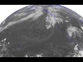
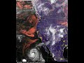
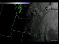
Infrared Satellite of Hurricane Odile and King Fire
- Title
- Infrared Satellite of Hurricane Odile and King Fire
- Date posted
- 12 years ago
- Description
- Infrared satellite imagery over the past 4 days showing the evolution of Hurricane Odile and weather across the western United States. This imagery shows the temperature of the cloud tops or ground surface. Can you see the King Fire in the satellite imagery? It shows up as a little black dot, signifying the heat of the fire! Best viewed in HD and full screen.
- Title
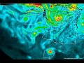
- Surface wind visualization of Hurricane Odile
- Date posted
- 12 years ago
- Description
- Surface wind visualization of Category 3 Hurricane Odile making landfall near Cabo San Lucas. Maximum sustained winds are near 120mph with higher gusts. Best viewed in full screen and HD! Courtesy of http://earth.nullschool.net/

- Title
- Modeled Aurora over the past 24 hours.
- Date posted
- 12 years ago
- Description
- Modeled Aurora Forecast over the past 24 hours. It appears the main wave of energy passed over the Earth's Magnetosphere around 0:00 UTC 9/13 (6pm Mountain Daylight Time) earlier this evening...the same time you can see the red in the image. It appears we just missed out seeing the aurora by 6 hours or so because of the position of the sun and subsequent daylight. We will continue to monitor and will provide an update if anything changes!

- Title
- Aurora Forecast 9-12-2014
- Date posted
- 12 years ago
- Description
- Here is a current model forecast of the Aurora for the next 24 hours. This model is the OVATION-Prime Model from the NOAA NWS Space Weather Prediction Center. Let us know if you see anything or have any photos!

- Title
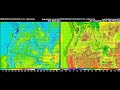
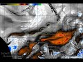
- Flash flooding in Desert Southwest, Snow in Alberta
- Date posted
- 12 years ago
- Description
- Very interesting weather pattern going on right now. Remnants of former Hurricane Norbert (now a post-tropical cyclone) are moving up over the desert southwest with flash flooding in these areas. A strong cold front is also moving southward and beginning to impact Alberta in Canada, with snow falling behind the front at Calgary this morning. We will stay dry and relatively cool here in southwest Idaho and southeast Oregon. This is a model depiction of the airmasses combined with precipitation areas. The shading refers to warm areas (red) and cool areas (blue). Precipitation areas are overlaid on the airmass colors. Can you see where the fronts are? We thought you might find this interesting.
- Title
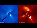
- LASCO Imagery of Coronal Mass Ejection on Sun 9/1/14
- Date posted
- 12 years ago
- Description
- An eruption occurred earlier today on the Sun. However, this event occurred on the back side - from an Earth perspective.
Shown here is 2 LASCO coronagraph images, the plasma cloud in the process of quickly blasting away from the Sun. The flat grey disk in the center of the image is known as an occulting disk, used to create a false eclipse, allowing analysis of the fine structures in the suns outer atmosphere, the Corona. Without this eclipse, the brightness of the Sun would saturate and overpower observation. NOAA NWS Space Weather Prediction Center forecasters analyze events like this, to determine if they have the potential to impact the Earth's magnetosphere or not.
In this instance, the event looks to be headed out away from Earth.
- Title
- Model depiction of 8/30/14 cold front over SW Idaho and SE Oregon
- Date posted
- 12 years ago
- Description
- Modeled depiction of the cold front we had last night from experimental high resolution numerical models that we use to forecast. This video shows surface temperature and surface wind. Can you pick out the cold front? Best viewed in full screen HD.
- Title
- GeoColor Imagery of Hurricane Marie
- Date posted
- 12 years ago
- Description
- GeoColor satellite image of Western North America showing Hurricane Marie moving NW while weakening into a tropical storm. Geocolor imagery shows visible satellite imagery during the day and infrared during the night. The imagery depicts clouds and snow cover (when present) in white, moonlit nighttime terrain in purple, city lights from major metropolitan areas in yellow, low clouds/fog during the night time in red, and daytime land and shallow-water features in true color.

- Title
- 1-minute visible and infrared satellite imagery of the Elk/Pony Complex Fire
- Date posted
- 12 years ago
- Description
- 1-minute visible and infrared satellite imagery of the Elk/Pony Complex Fire last summer in Elmore County. These fires produced pyrocumulus clouds which extended up to 45,000 feet! Best viewed in HD full screen. #idwx
- Title
- Fujiwhara Effect
- Date posted
- 12 years ago
- Description
- Interesting weather feature in the models depicting a 'Fujiwhara Effect' in the Eastern Pacific late this weekend. The Fujiwhara Effect is when two tropical cyclones interact with each other and rotate counterclockwise (cyclonically) about each other.

- Title
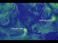
- Northern Hemisphere Satellite View
- Date posted
- 12 years ago
- Description
- In case you ever wondered how complex weather is...here is a look at a satellite view of the Northern Hemisphere across the span of 6 days. There is a lot going on! This satellite shows the amount of water vapor in the upper atmosphere with red areas indicating dryness while white and blue indicate moist areas in the upper atmosphere. We've annotated the tropical systems.
- Title
- Water Vapor Imagery 8/8/2014
- Date posted
- 12 years ago
- Description
- Interesting weather pattern today across the Eastern Pacific Ocean. Super Typhoon #Genevieve, Tropical Storm #Iselle hitting Hawaii, Hurricane #Julio as well as a polar upper level low causing stratospheric intrusion vortices along the interface between the tropical and subtropical air mass.
- Title
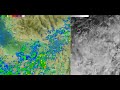
- Mesolow over Magic Valley
- Date posted
- 12 years ago
- Description
- Neat little feature we noticed today in the Magic Valley called a meso-low pressure system, which helped produce heavy rains in the Magic Valley. This is a radar overlay and visible satellite image best viewed in HD.

- Title
- Shoshone falls illusion
- Date posted
- 12 years ago
- Description
- Here is a webcam at Shoshone Falls where the angle of the sun created an optical illusion of filling up the pool below the waterfall like a bathtub.

- Title
- Weather model that simulates smoke
- Date posted
- 12 years ago
- Description
- Here is an EXPERIMENTAL research weather model tool that simulates the movement of smoke using fire locations and characteristics along with upper level winds. Blue icons represent fires within the model. PLEASE NOTE: this is a research tool and may not accurately reflect actual smoke due to numerous reasons. Courtesy of the U.S. Forest Service Pacific Northwest Research Station AirFire Team.
- Title
- Current satellite view of the Smoke over Pacific NW (7-17-14)
- Date posted
- 12 years ago
- Description
- Visible satellite animation depicting the smoke this morning across the Pacific Northwest. The smoke is depicted as an opaque gray over much of the Pacific Northwest extending from Central Oregon & Washington into Montana and Wyoming. Clouds are depicted as a bright white.

- Title
- Sunrise Time-lapse
- Date posted
- 12 years ago
- Description
- Sunrise Time-lapse video at Boise on July 10, 2014.

- Title
- May 18, 2014: Water Vapor Loop with Lightning
- Date posted
- 12 years ago
- Description
- One of the tools we use to monitor severe weather is Water Vapor Satellite imagery. Here is a water vapor satellite loop showing lightning in green. Notice the dangerous storms that developed in Eastern MT and WY.

- Title
- Redfish Lake ice breakup
- Date posted
- 12 years ago
- Description
- Short time-lapse of the ice breaking up at Redfish Lake from May 14-16, 2014. Courtesy of the Sawtooth Interpretive & Historical Association. http://new.discoversawtooth.org/

- Title
- Pacific Northwest Flash Flood Awareness 2014
- Date posted
- 12 years ago
- Description
- Troy Lindquist discusses Flash Floods in the Pacific Northwest for 2014 Severe Weather Awareness Week for the Pacific Northwest.
-------------------------
National Weather Service
Weather Forecast Office
Boise, ID
http://weather.gov/Boise

- Title
- Winter Arrives in Idaho Mountains - 3 day time lapse
- Date posted
- 13 years ago
- Description
- The National Weather Service in Boise created an awesome three day time-lapse of Redfish Lake near Stanley, ID using web camera images courtesy of the Sawtooth Interpretive and Historical Association (SIHA) http://new.discoversawtooth.org/webcam Fall is changing to winter in the Idaho mountains with early morning fog visible over the relatively warmer lake each morning. A little bit of light snow adds to the beauty.
-------------------------
National Weather Service
Weather Forecast Office
Boise, ID
http://weather.gov/Boise
- Title
- Pacific Northwest Winter Weather Awareness - Watches, Warnings and Advisories
- Date posted
- 13 years ago
- Description
- National Weather Service meteorologist Jay Breidenbach discusses watches, warnings and advisories commonly issued during the winter season across the Pacific Northwest.

- Title
- ITD Webcam's View of the Pony Complex on 8.9.13
- Date posted
- 13 years ago
- Description
- Idaho Transportation Department webcam at Hammett Hill (east of Mountain Home, Idaho) catches images of the Pony Complex on Friday, August 9th, 2013.
- Title
- Major heat wave expected for late June and early July.
- Date posted
- 13 years ago
- Description
- National Weather Service meteorologist Jay Breidenbach discusses a major heat wave expected to impact southeast Oregon and southwest Idaho from Friday June 29 through at least Wednesday July 3.
-------------------------
National Weather Service
Weather Forecast Office
Boise, ID
http://weather.gov/Boise

- Title
- Severe Weather Awareness Week: Flash Flood Preparedness
- Date posted
- 13 years ago
- Description
- Senior Hydrologist Troy Lindquist discusses the difference between flooding and flash flooding, and their impacts in the Pacific Northwest. Troy also provides information to keep you and your family safe should flash flooding occur in your area.
-------------------------
National Weather Service
Weather Forecast Office
Boise, ID
http://weather.gov/Boise