NWS Boise, ID
GOES R - Mar 2, 2017

- Title
- GOES R - Mar 2, 2017
- Date posted
- 7 years ago
- Description
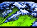
- We started receiving GOES-R (Geostationary Operational Environmental Satellite - R Series) data today. Spatial and temporal resolution is much improved, with new data every 5 minutes, with the ability for 1 minute data on critical weather days.
The GOES-16 data posted on this page are preliminary, non-operational data and are undergoing testing. Users bear all responsibility for inspecting the data prior to use and for the manner in which the data are utilized.
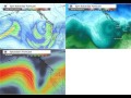
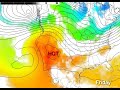
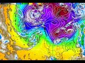
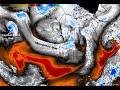
- Title
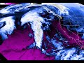
- Active storm pattern setting up over the Pacific Northwest into Thanksgiving weekend.
- Date posted
- 8 years ago
- Description
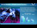
- Active storm pattern setting up over the Pacific Northwest into Thanksgiving weekend. Snow levels will lower next week, possibly to the valley floors. Significant mountain snow is also possible. Stay tuned for details!
The first panel shows modeled moisture, second panel on top shows the temperature around 5000 feet (a good measure for snow levels), and bottom panel shows the jet stream. Notice the active jet stream and colder temperatures aloft moving into the Pacific Northwest. Best viewed in full screen and HD.
- Title
- Snow Storms, Blizzards, Ice Storms, Avalanches in the Pacific Northwest
- Date posted
- 8 years ago
- Description
- Common winter weather hazards in the Pacific Northwest. It includes basic information on these hazards and a few tips on how to prepare and stay safe this winter season.
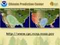
- Title
- Winter Weather Awareness: Watches, Warnings and Advisories
- Date posted
- 8 years ago
- Description
- 2016 Pacific Northwest Winter Weather Awareness: Warning Coordination Meteorologist, Jay Breidenbach, discusses watches, warnings and advisories commonly issued during the winter season across the Pacific Northwest.

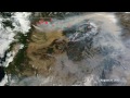
- Title
- Pioneer Fire Soil Water Repellency Demonstration
- Date posted
- 8 years ago
- Description
- Flash flooding, debris and mud flow danger is enhanced around the Pioneer Fire burn scar. Burnt vegetation has altered the soil properties in that the ground is unable to absorb rainfall effectively in portions of the burned area. Without vegetation to hold the soil in place, heavy rain can produce mud and debris flows. When normally dry soil becomes overly saturated, it can reach a point where it turns to a liquid state and flows downhill, essentially becoming a river of mud. Mud and debris flows can destroy homes, wash out bridges and roadways, and knock down trees. They can also deposit large amounts of mud and other debris on previously clear surfaces, damaging or burying everything in their path.
- Title
- Turn Around Don't Drown - Public Service Annoucement
- Date posted
- 8 years ago
- Description
- Flooding is one of the leading causes of weather related fatalities in the U.S. On average, flooding claims nearly 90 lives each year. More than half of these deaths occur in motor vehicles when people attempt to drive through flooded roadways. This happens because people underestimate the force and power of water, especially when it is moving.
Just six inches of fast-moving water can knock over and carry off an adult. Twelve inches of water can float a small car. If that water is moving, it can carry that car away. Eighteen to twenty-four inches of flowing water can carry away most vehicles, including large SUVs. It is impossible to tell the exact depth of water covering a roadway or the condition of the road below the water. This is especially true at night when your vision is more limited. It is never safe to drive or walk through flood waters. Any time you come to a flooded road, walkway, or path, follow this simple rule: Turn Around Don’t Drown.

- Title
- What is GOES-R?
- Date posted
- 8 years ago
- Description
- The GOES-R series, NOAA's next-generation geostationary weather satellites, is a game changer. These satellites, beginning with the launch of GOES-R on November 4, 2016, will provide continuous imagery and atmospheric measurements of Earth’s Western Hemisphere, total lightning data, and space weather monitoring to provide critical atmospheric, hydrologic, oceanic, climatic, solar and space data. These measurements will lead to significant improvements in the detection and observations of meteorological phenomena that directly affect public safety, protection of property and our GOES fleet in the GOES-R era nation’s economic health and prosperity.

- Title
- 2015 Pacific Northwest Winter Weather Awareness - Watches, Warnings and Advisories
- Date posted
- 9 years ago
- Description
- Warning Coordination Meteorologist, Jay Breidenbach, discusses watches, warnings and advisories commonly issued during the winter season across the Pacific Northwest.
- Title
- MODIS Imagery of the Wildfire Smoke in Pacific Northwest
- Date posted
- 9 years ago
- Description
- A collection of MODIS images over the past 30 days showing progression of wildfires (red dots) and smoke over the Pacific Northwest. Best viewed in HD and full screen.
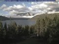
- Title
- Thunderstorms, fog at Redfish Lake
- Date posted
- 9 years ago
- Description
- Check out this time-lapse video over the past 2 days at Redfish Lake. You can see thunderstorms the past 2 afternoons, gusty winds, and fog early this morning over the lake clearing out. Please watch in full screen and HD. Webcam courtesy of Sawtooth Interpretive and Historical Association (SIHA)
- Title
- Heatwave 2015
- Date posted
- 9 years ago
- Description
- Record high temperatures are likely to occur next weekend with valley temperatures in the 100s! A strong upper level ridge will develop over the Western United States. Stay tuned for details on this developing situation! With this weather pattern, June 2015 is likely to be the warmest June on record in Boise.

- Title
- June 21 Coronal Mass Ejection
- Date posted
- 9 years ago
- Description
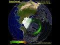
- A coronal mass ejection occurred June 21. There is a chance we could see the aurora tonight in the Pacific Northwest once it gets dark! Stay tuned! This is the WSA-Enlil Solar Wind Prediction model from the NOAA NWS Space Weather Prediction Center.
WSA-Enlil is a large-scale, physics-based prediction model of the heliosphere, used by the Space Weather Forecast Office to provide 1-4 day advance warning of solar wind structures and Earth-directed coronal mass ejections (CMEs) that cause geomagnetic storms. Solar disturbances have long been known to disrupt communications, wreak havoc with geomagnetic systems, and to pose dangers for satellite operations.
In the movie, the Sun is represented as a yellow dot, the Earth by a green dot, and the STEREO spacecraft by the red and blue dots. The top row represents the WSA-Enlil predicted solar wind density and the bottom row the predicted solar wind velocity. On the left is a pinwheel plot of the ecliptic plane, showin...
- Title
- Wildland Fire Weather in Pacific Northwest
- Date posted
- 9 years ago
- Description
- Jay Breidenbach, meterorolgist, with NOAA's National Weather Service, talks about the wildland fire season in the Pacific Northwest. Hot, dry, windy weather and thunderstorms can lead to dangerous fire behavior when the forests and range lands are dry during the summer months. Learn what you can do to stay safe and help prevent fires from starting.
-------------------------
National Weather Service
Weather Forecast Office
Boise, ID
http://weather.gov/Boise
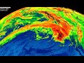
- Title
- May 9, 2015 - Snow storm, severe weather & Tropical Storm Ana
- Date posted
- 9 years ago
- Description
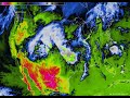
- Enjoy the nice fair weather that we are currently having! It is not every day that you see a major snow storm bearing down on Colorado, Wyoming and Western SD and NE with up to 2 feet of snow expected, along with severe weather in the plains, and a Tropical Storm (Ana) just off the Eastern seaboard. This image depicts satellite observed temperature of clouds and ground surface where there are no clouds. Lightning is shown in green/yellow dots.

- Title
- 2015 Pacific Northwest Flash Flood Awareness
- Date posted
- 9 years ago
- Description
- Troy Lindquist discusses Flash Floods in the Pacific Northwest. Flash floods are a common occurrence from summertime thunderstorms across the Pacific Northwest.

- Title
- IR Satellite 4-11-2015
- Date posted
- 9 years ago
- Description
- A cold front will move through the region later this afternoon bringing rain, mountain snow and breezy conditions. Dry weather returns by Sunday and temperatures back up in the 70s in valley locations on Monday.
- Title
- Strong cold front expected Tuesday, March 31
- Date posted
- 9 years ago
- Description
- Enjoy your Monday with temperatures 15-20 degrees above normal! A strong cold front will move through the region Tuesday bringing gusty winds up to 40 mph and below normal temperatures by Wednesday.
- Title
- G4 (severe) geomagnetic storm - March 17, 2015
- Date posted
- 9 years ago
- Description
- Check out the aurora based on a model from the NOAA NWS Space Weather Prediction Center. It was a G4 (severe) geomagnetic storm early this morning through this afternoon. We would have seen the Aurora in Boise, and the rest of southwest Idaho and southeast Oregon if there weren't clouds blocking the view 🙁

- Title
- IR Satellite 3-11-2015
- Date posted
- 9 years ago
- Description
- Infrared satellite shows a weather system now moving onto the West Coast that will move through the region Wednesday bringing showers and mountain snow above 6500 feet MSL.

- Title
- Welcome to Daylight Saving Time!
- Date posted
- 9 years ago
- Description
- While most of you were sleeping, we experienced the time warp at NWS Boise. Welcome to Daylight Saving Time!
- Title
- Unsettled weather on the way.
- Date posted
- 9 years ago
- Description
- IR satellite shows one of several disturbances that will move across the region Thursday through Saturday. These systems will bring valley rain and mountain snow over the next several days.

- Title
- Record temperatures continue to be broken
- Date posted
- 9 years ago
- Description
- Many record temperatures have been observed with this current weather pattern. Here is the current infrared satellite showing a large ridge off the west coast. Record warmth continues to extend from the Western U.S. north to Alaska, while record cold continues to impact the eastern United States. Records shown are from yesterday and today.

- Title
- Nor Easter
- Date posted
- 9 years ago
- Description
- Current infrared satellite shows a powerful Nor Easter developing off the eastern seaboard. Lightning is shown in red. Our next weather system will arrive from the south Tuesday night into Wednesday across southwest Idaho and eastern Oregon.
- Title
- IR Satellite 1/17
- Date posted
- 9 years ago
- Description
- A powerful storm is now moving onto the Pacific Northwest coast. The strongest part of the storm will move into Western WA tonight, but expect rain and high mountain snow as this system passes through. Be sure to check the latest forecast on our website.

- Title
- IR Satellite 1/15/15
- Date posted
- 9 years ago
- Description
- Current satellite imagery shows moisture streaming in from the Pacific Ocean. The upper level high pressure which provided the inversion has moved east. Snow will move into Eastern Oregon late this evening and into Southwest Idaho after midnight. The lower Treasure Valley will see 1-3 inches while the West Central Mountains will see 4-8 inches. Upper Treasure Valley could see up to an inch of snow changing to rain by late morning.
- Title
- IR Satellite 1/13/15
- Date posted
- 9 years ago
- Description
- High pressure is building into the region. Temperatures will warm aloft creating 'inversion' conditions once again. The high pressure aloft will break down by Friday allowing unsettled weather to move inland from the Pacific Ocean for the weekend.

- Title
- Redfish Lake freeze up 2014
- Date posted
- 9 years ago
- Description
- Time lapse video of Redfish Lake becoming ice-covered over the span of 4 days, from 12-26-2014 to 12-30-2014. Webcam courtesy of Sawtooth Interpretive and Historical Association (SIHA): http://discoversawtooth.org/webcam

- Title
- Inversion conditions forming on Satellite
- Date posted
- 9 years ago
- Description
- Inversion conditions are currently forming and are expected to remain through at least Saturday. Fog is currently expanding and is shown in pink. This is a IR satellite that can detect where fog is forming when there are clear skies. In this video the cold valley floors show up as light blue, the relatively warmer mountains showing up as dark blue and the fog showing up as a pink enhancement.

- Title
- A little about Treasure Valley inversions
- Date posted
- 9 years ago
- Description
- Amaze friends and family with your knowledge of Treasure Valley weather inversions. David Staats of the Idaho Statesman interviews one of our Meteorologists, Jay Breidenbach.
- Title
- Current IR Satellite imagery
- Date posted
- 9 years ago
- Description
- Current satellite imagery shows our next weather system moving southeast from the Gulf of Alaska into the Pacific Northwest.
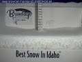
- Title
- Snow accumulation at Brundage Mountain and Bogus Basin
- Date posted
- 9 years ago
- Description
- Always interesting seeing how snow accumulates and melts. Here are the webcams at Brundage Mountain Resort and Bogus Basin Mountain Recreation Area over the past 24 hours.
- Title
- IR Imagery of Atmospheric River over Pacific Northwest 12/20/2014
- Date posted
- 9 years ago
- Description
- Dec 20, 2014: A powerful Pacific storm is impacting the Pacific Northwest. Current infrared satellite loop shows an impressive atmospheric river, bringing heavy rain and mountain snow to the region.
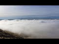
- Title
- Boise fog as seen from Table Rock
- Date posted
- 10 years ago
- Description
- Time lapse video taken from Table Rock this morning looking towards the Boise Airport and Owyhee Mountains. A different perspective of the fog rolling into Boise. For best results watch in HD.

- Title
- Treasure Valley Cold Pool
- Date posted
- 10 years ago
- Description
- Here is a 30 minute time-lapse from our office today looking towards the Boise foothills showing fog rolling in from the lower Treasure Valley over Boise. Relatively colder air remains trapped in the lower Treasure Valley near Ontario (called a cold pool) and fog like this is an indication of the cold air undercutting the warm air aloft. This phenomenon poses significant weather forecasting challenges in the winter.
- Title
- 7" of snow at Brundage since last night.
- Date posted
- 10 years ago
- Description
- Around 7" of snow at Brundage Mountain Resort since 8pm last night! Please exercise caution this morning, for snow covered roads, if traveling on Highway 55 north of Horseshoe Bend or Highway 95 north of Weiser.

- Title
- Bogus Basin Drifiting
- Date posted
- 10 years ago
- Description
- Check out the blowing snow at Bogus Basin today.

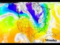
- Title
- Much cooler weather by Monday
- Date posted
- 10 years ago
- Description
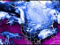
- Much COOLER weather on the way for Southwest Idaho and Southeast Oregon! A strong cold front will move through the region late tomorrow night into Monday morning. The storm up by Alaska will form a blocking high pressure over Western North America which will allow the jet stream to push cold arctic air southward over our area.
This graphic shows the air mass temperatures with areas of precipitation in grey, blue, and green shading. Air mass temperatures cold enough for snow are where the sky blue colors change to dark blue. The jet stream flows parallel to the white lines and is strongest where the lines are tightly spaced together.
- Title
- Nuri controls weather for most of Northern Hemisphere
- Date posted
- 10 years ago
- Description
- Interesting weather pattern for everywhere around us. A strong low pressure in the Bering Sea (Remnants of Typhoon #Nuri) will control the weather for most of the Northern Hemisphere.
What this means for us is drier than normal conditions and above normal temperatures as a ridge of high pressure builds across the West.
If you are wondering where winter is, it will be making an appearance east of the Rocky Mountains starting Sunday over much of the Eastern United States. This graphic shows the air mass temperatures with areas of precipitation in grey, blue, and green shading. Air mass temperatures cold enough for snow are where the sky blue colors change to dark blue. The jet stream flows parallel to the white lines and is strongest where the lines are tightly spaced together.

- Title
- Tropical Storm Nuri becoming monster extratropical cyclone
- Date posted
- 10 years ago
- Description
- Relatively benign weather can be expected over the next week as a result of Tropical Storm Nuri perturbing the Jet Stream, building a ridge over the Western United States and our area...with cold weather east of the Rockies. A potentially dangerous storm is forecast for the Bering Sea later this week. The remnants of Tropical Storm Nuri will interact with cold Arctic Air over the Bering Sea of Western Alaska.
Areas in and near the Western and Central Aleutians will likely see the highest wind and waves. Hurricane force wind and seas of 45 to 50 feet are possible Friday and Saturday. Gusts to 100 mph are not out of the question near Shemya and Attu.
Here is a wind map courtesy of http://earth.nullschool.net/#2014/11/08/0000Z/wind/surface/level/orthographic=-173.81,47.01,827
For updates on this storm, follow our colleagues at www.youtube.com/NWSAnchorage

- Title
- Winter arrives at Redfish Lake
- Date posted
- 10 years ago
- Description
- Winter arrived at Redfish Lake this morning with a fresh coating of snow!
- Title
- Water Vapor Imagery - October 23, 2014
- Date posted
- 10 years ago
- Description
- Today's water vapor imagery shows an atmospheric river bringing record rainfall to the Pacific Northwest in Western Oregon and Western Washington. We will see rain with this system through Friday morning.

- Title
- Oct 21, 2014 Morning Radar
- Date posted
- 10 years ago
- Description
- Radar loop of the rain and mountain snow early this morning across southwest Idaho and southeast Oregon.

- Title
- Oct 14, 2014 IR Satellite and Air Mass Map
- Date posted
- 10 years ago
- Description
- Current infrared satellite combined with model air mass temperatures. Cooler temperatures are in blues, warmer temperatures in reds. The storm off the Pacific Northwest coast will bring us cooler air and precipitation for Wednesday.

- Title
- Northern Lights Oct 8
- Date posted
- 10 years ago
- Description
- Check out these northern lights captured by one of our forecasters in Anchorage, AK during the Lunar Eclipse last week.

- Title
- Oct 3 IR Satellite and air mass map
- Date posted
- 10 years ago
- Description
- Current infrared satellite combined with model air mass temperatures. Cooler temperatures are in blues, warmer temperatures in reds. The ridge of high pressure is building along the West Coast and a strong cold front is impacting the Great Plains with snow in Minnesota.
- Title
- Air mass and clouds map for next 7 days
- Date posted
- 10 years ago
- Description
- A ridge of high pressure will build across the western United States this week for dry conditions and above normal temperatures through early next week. Here is a map depicting the air masses (shown in color: cold in blue/purple, warm in orange, etc.) and clouds in the upper atmosphere (shaded in gray and white). Can you tell where the fronts are?

- Title
- Roll Clouds over Boise
- Date posted
- 10 years ago
- Description
- Some pretty cool clouds over the office this afternoon. These clouds indicate high wind speeds aloft (strong jet stream) and a lot of turbulence for people flying in this area due to wind shear.

- Title
- Impressive storm over NE Pacific Ocean.
- Date posted
- 10 years ago
- Description
- Impressive storm just off the Pacific Northwest coast which produced a small area of hurricane force winds earlier today and wave heights up to 34 feet! The central pressure of the storm was 973mb. Here is a wind map visualization from this evening (9/23). Can you see where the cold front is over the ocean? http://earth.nullschool.net/

- Title
- King Fire smoke & Haze continues to impact SW Idaho and SE Oregon
- Date posted
- 10 years ago
- Description
- Still smoky and hazy conditions across southwest Idaho and southeast Oregon from the #KingFire in #California. Here is an updated EXPERIMENTAL research weather model that simulates the movement of smoke using fire locations and characteristics along with upper level winds to project smoke movement and dispersion.

- Title
- Satellite imagery of rapid King Fire growth
- Date posted
- 10 years ago
- Description
- Infrared satellite imagery showing the impressive growth of the King Fire in California. It grew over 50,000 acres in 24 hours and is the reason for all the hazy smoke in the air!